IMAGES TAKEN NEAR TO
Barclay Street, GLASGOW, G60 5DF
Introduction
This page details the photographs taken nearby to Barclay Street, G60 5DF by members of the Geograph project.
The Geograph project started in 2005 with the aim of publishing, organising and preserving representative images for every square kilometre of Great Britain, Ireland and the Isle of Man.

There are currently over 7.5m images from over14,400 individuals and you can help contribute to the project by visiting https://www.geograph.org.uk
Image Map
Images are licensed for reuse under creativecommons.org/licenses/by-sa/2.0
Notes
- Clicking on the map will re-center to the selected point.
- The higher the marker number, the further away the image location is from the centre of the postcode.
Image Listing (156 Images Found)
Images are licensed for reuse under creativecommons.org/licenses/by-sa/2.0
Image
Details
Distance
1
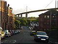
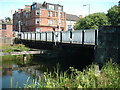
Barclay Street, Old Kilpatrick
Nice view of not only the Erskine Bridge, but of The Saltings, a small nature reserve in the village under the bridge itself.
Image: © Stephen Sweeney
Taken: 20 May 2007
0.01 miles
2
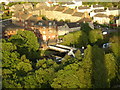
Old Kilpatrick from Erskine Bridge
The village viewed from several feet above.
Image: © Stephen Sweeney
Taken: 20 May 2007
0.02 miles
3
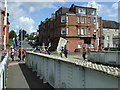
CND protesters
Passing the Forth & Clyde Canal swing bridge in Old Kilpatrick.
Image: © Thomas Nugent
Taken: 7 Aug 2010
0.02 miles
4
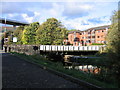
Erskine Ferry Road bridge, Forth & Clyde Canal
This swing bridge, which once carried road traffic to the vehicle ferry that crossed the Clyde from Old Kilpatrick to the Renfrewshire shore, was restored in 2001 as part of the Millennium Link project to re-open Scotland's Lowland Canals. In the left background is the ferry's replacement, a high-level bridge (though a few years ago it proved not quite high-level enough for everything that might sail "doon the watter").
Image: © A-M-Jervis
Taken: 13 Oct 2007
0.03 miles
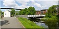
5
Dalnottar Bridge
Spans Forth & Clyde canal leading to Old Erskine ferry skipway
Image: © william craig
Taken: Unknown
0.03 miles
6

Swans on the Forth and Clyde Canal
Swans on the Forth & Clyde Canal. The bridge carries Erskine Ferry Road over the canal.
Image: © Tim Glover
Taken: 31 Dec 2007
0.03 miles
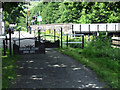
7
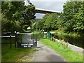
Swing bridge at Old Kilpatrick
The bridge is on the Forth and Clyde Canal. Unlike the bascule bridges to be seen nearby on the canal (see, for example, Image), this one pivots around a vertical axis.
Erkine Ferry Road crosses the canal by means of this bridge. The Erskine Bridge is prominent in the background. The route receding directly from the photographer's position is the cycle route.
For the building on the left, see Image; according to text that is etched onto its windows, it dates from "c.1842" (the occupant informed me that the authority for this date is the house's title deeds).
I have submitted this fairly wide view to show the bridge in context, and in relation to nearby structures, but there are several earlier pictures of it; see those for more information: Image / Image / Image
Image: © Lairich Rig
Taken: 17 Jun 2013
0.04 miles
8
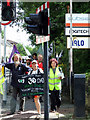
CND protesters
The Footprints For Peace Walk Across Scotland reaches Old Kilpatrick on the way to Faslane presumably.
Image: © Thomas Nugent
Taken: 7 Aug 2010
0.04 miles
9
Forth & Clyde Canal
The road to the Erskine Ferry crosses the canal on a swing bridge here. The ferry closed in 1971 when the Erskine Bridge opened.
Image: © Thomas Nugent
Taken: 7 Aug 2010
0.04 miles
10
Cycle route at Old Kilpatrick
Erskine Ferry Road cuts across the cycle route here, and there are barriers on either side of the road; one set is shown here, and the other in Image The Erskine Bridge can be seen in the background.
Image: © Lairich Rig
Taken: 14 Sep 2012
0.04 miles