IMAGES TAKEN NEAR TO
Dumbarton Road, GLASGOW, G60 5BQ
Introduction
This page details the photographs taken nearby to Dumbarton Road, G60 5BQ by members of the Geograph project.
The Geograph project started in 2005 with the aim of publishing, organising and preserving representative images for every square kilometre of Great Britain, Ireland and the Isle of Man.

There are currently over 7.5m images from over14,400 individuals and you can help contribute to the project by visiting https://www.geograph.org.uk
Image Map
Images are licensed for reuse under creativecommons.org/licenses/by-sa/2.0
Notes
- Clicking on the map will re-center to the selected point.
- The higher the marker number, the further away the image location is from the centre of the postcode.
Image Listing (118 Images Found)
Images are licensed for reuse under creativecommons.org/licenses/by-sa/2.0
Image
Details
Distance
1
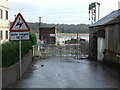
Bowling level crossing
Slightly west of Bowling station. Now locked from public use, it once led to the Scott of Bowling shipyard.
Image: © Thomas Nugent
Taken: 2 Mar 2008
0.01 miles
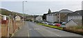
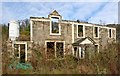
2
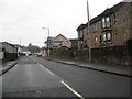
Heading through Bowling in West Dunbartonshire
The building with the scaffolding is a former inn which is being repaired, maybe reopening?
Image: © James Denham
Taken: 24 Nov 2013
0.01 miles
5
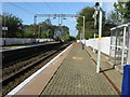
Bowling railway station, looking West
View from platform 1 at Bowling railway station, looking roughly West towards Dumbarton, Helensburgh, Balloch and the West Highland Line to Oban, Fort William and Mallaig.
Image: © Andrew Reid
Taken: 22 Sep 2011
0.03 miles
6
The former site of the Littlemill Distillery
The main distillery buildings were located on the right-hand side (south side) of the road, where modern housing now stands, but the shell of the Exciseman's House could, when this picture was taken, still be seen to the left of the road. It is behind the large upright white mixer, and, in this view, is largely obscured by the fencing; the building is shown separately: Image and Image
This was originally the site of the Little Mill, the mill of Auchentorlie, powered by Image; see that item for more details. The mill fell into disuse, and Littlemill Distillery then occupied the same site. It closed in the 1990s, but the name survives in Littlemill Lane, which is not far ahead, to the left of the road, and in Image, which is a little way back along the road.
Image: © Lairich Rig
Taken: 8 Feb 2013
0.04 miles
7

Bowling station car park
Car park at Bowling railway station.
Image: © Andrew Reid
Taken: 22 Sep 2011
0.05 miles
8
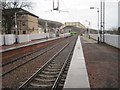
Bowling railway station, West Dunbartonshire
Opened in 1858 by the Caledonian and Dunbartonshire Junction Railway on its line from here to Balloch Pier. View east towards Kilpatrick and Glasgow.
Image: © Nigel Thompson
Taken: 29 Dec 2012
0.05 miles
9
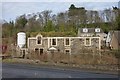
Littlemill Distillery: remains of the exciseman's house
For context, see Image; with respect to that view, the ruin shown here is to the left (north) of the main road. See the first link in the end-note for a picture of the house as it looked when it was intact; the second of the links explains why the house was built.
For a closer look at the ruin, see Image, taken through the fence that is in front of the house.
Image: © Lairich Rig
Taken: 8 Feb 2013
0.05 miles
10
Littlemill Distillery: remains of the exciseman's house
For a wider view, see Image For context, see Image; the building is to the left (north) of the main road. The ruin is behind a fence (this is a view through the fence).
The first and second links in the end-note give, respectively, a view of the intact house, and the reason why it was built.
Image: © Lairich Rig
Taken: 8 Feb 2013
0.05 miles