IMAGES TAKEN NEAR TO
G60 5AX
Introduction
This page details the photographs taken nearby to G60 5AX by members of the Geograph project.
The Geograph project started in 2005 with the aim of publishing, organising and preserving representative images for every square kilometre of Great Britain, Ireland and the Isle of Man.

There are currently over 7.5m images from over14,400 individuals and you can help contribute to the project by visiting https://www.geograph.org.uk
Image Map
Images are licensed for reuse under creativecommons.org/licenses/by-sa/2.0
Notes
- Clicking on the map will re-center to the selected point.
- The higher the marker number, the further away the image location is from the centre of the postcode.
Image Listing (99 Images Found)
Images are licensed for reuse under creativecommons.org/licenses/by-sa/2.0
Image
Details
Distance
1
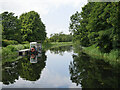
Forth and Clyde Canal
The canal running beside Portpatrick Road. This is the site of the western end of the Antonine Wall.
Image: © Richard Webb
Taken: 1 Sep 2009
0.04 miles
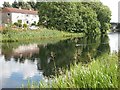
2
The Forth and Clyde Canal at Old Kilpatrick
The houses are on Portpatrick Road.
Image: © Thomas Nugent
Taken: 27 Apr 2015
0.05 miles
3
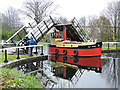
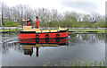
Wee Spark at Old Kilpatrick
Wee Spark is a diesel powered one third scale replica of a Clyde puffer. Seen here in the rain passing through Ferrydyke bascule bridge on the Forth & Clyde Canal at Portpatrick Road.
The bridge is a Category B Listed structure http://data.historic-scotland.gov.uk/pls/htmldb/f?p=2200:15:0::::BUILDING:14410 .
See also Image
Image: © Thomas Nugent
Taken: 27 Apr 2015
0.05 miles
4
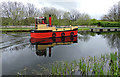
Wee Spark at Old Kilpatrick
Heading west, having just passed through Ferrydyke bascule bridge on the Forth and Clyde Canal. See also Image
Image: © Thomas Nugent
Taken: 27 Apr 2015
0.05 miles
5
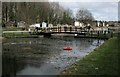
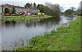
Forth & Clyde Canal adjacent to Portpatrick Road, Old Kilpatrick
Looking westward from a bridge over the Forth & Clyde Canal adjacent to Portpatrick Road, Old Kilpatrick. The vessel moored at the pontoon is for the removal of vegetation and was at work an hour previously.
This photograph was taken during the Coronavirus (COVID-19) pandemic of 2020/21.
Image: © James T M Towill
Taken: 2 Jul 2021
0.05 miles
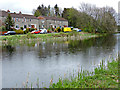
6
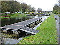
The Forth and Clyde Canal at Old Kilpatrick
Moorings at the west side of Ferrydyke bascule bridge.
Image: © Thomas Nugent
Taken: 27 Apr 2015
0.06 miles
7
Wee Spark at Old Kilpatrick
Heading west, having just passed through Ferrydyke bascule bridge on the Forth and Clyde Canal. See also Image
Image: © Thomas Nugent
Taken: 27 Apr 2015
0.06 miles
8
Bascule bridge, Ferrydyke
Bridge over the Forth and Clyde Canal https://canmore.org.uk/site/43318/forth-and-clyde-canal-ferrydyke-bascule-bridge, at the place where the canal crosses the line of the Antonine Wall, and a few yards from where the wall met the River Clyde.
Image: © Richard Sutcliffe
Taken: 29 Feb 2020
0.06 miles
9

Ferrydyke Bascule Bridge
This photo was taken from the cycle route that closely follows the Forth and Clyde Canal. The huts on the other side of the canal are in Portpatrick Road in Old Kilpatrick (compare Image).
The term 'bascule' comes from a French word meaning a see-saw. The two sides of a bascule bridge are raised independently by people who use long lever handles to turn the cogs. The heavy bridge decks are counterweighted with underground weights in order to make this process easier.
For a view across the bridge from the other side, see Image
Image: © Lairich Rig
Taken: 7 Feb 2007
0.06 miles
10
The Forth and Clyde Canal at Old Kilpatrick
The houses are on Portpatrick Road.
Image: © Thomas Nugent
Taken: 27 Apr 2015
0.06 miles