IMAGES TAKEN NEAR TO
Dumbarton Road, GLASGOW, G60 5AG
Introduction
This page details the photographs taken nearby to Dumbarton Road, G60 5AG by members of the Geograph project.
The Geograph project started in 2005 with the aim of publishing, organising and preserving representative images for every square kilometre of Great Britain, Ireland and the Isle of Man.

There are currently over 7.5m images from over14,400 individuals and you can help contribute to the project by visiting https://www.geograph.org.uk
Image Map
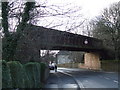
Images are licensed for reuse under creativecommons.org/licenses/by-sa/2.0
Notes
- Clicking on the map will re-center to the selected point.
- The higher the marker number, the further away the image location is from the centre of the postcode.
Image Listing (283 Images Found)
Images are licensed for reuse under creativecommons.org/licenses/by-sa/2.0
Image
Details
Distance
1
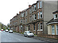
Tenement on Dumbarton Road
At the east end of Bowling, near the Forth and Clyde Canal basin.
Image: © Thomas Nugent
Taken: 27 Apr 2015
0.01 miles
2
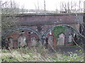
Bricked-up railway arches
Arches within arches under the former Lanarkshire & Dunbartonshire Railway line at the Forth & Clyde Canal basin in Bowling. See also Image
Image: © Thomas Nugent
Taken: 2 Mar 2008
0.01 miles
3
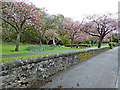
Park in Bowling
The village war memorial can be seen in the centre.
Image: © Thomas Nugent
Taken: 27 Apr 2015
0.01 miles
4
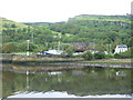
Doon The Watter - 25th June 2011 : Approaching Bowling Basin
Image: © Richard West
Taken: 25 Jun 2011
0.02 miles
5
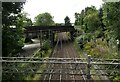
Old bridge over the railway
The bridge was built about 1896 to carry the Lanarkshire and Dumbartonshire Railway over the Glasgow Dumbarton and Helensburgh Line of the North British Railway (which is the current line).
Image: © Richard Sutcliffe
Taken: 11 Sep 2021
0.03 miles
6
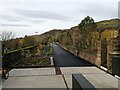
Looking along the Bowline
This new walking and cycling path runs along a disused railway viaduct. From just above the cafe and cycle shop, the picture looks west along the Bowline.
Image: © Alec MacKinnon
Taken: 25 Nov 2021
0.03 miles
7
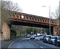
Disused railway bridge
Crosses Dumbarton Road in Bowling. Used to carry the Lanarkshire & Dunbartonshire Railway line. Closed in 1952.
See also Image & Image
Image: © Thomas Nugent
Taken: 2 Mar 2008
0.03 miles
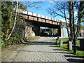
8
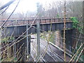
Railway Bridge
This bridge carried the Lanarkshire & Dunbartonshire Railway over the Caledonian & Dunbartonshire Junction Railway. The Lanarkshire & Dunbartonshire Railway is closed and the trackbed is now used for the Clyde and Loch Lomond Cycleway, part of route 7. The Caledonian & Dunbartonshire Junction Railway remains open as part of the North Clyde Line.
Image: © Tim Glover
Taken: 31 Dec 2007
0.03 miles
9
Disused railway bridge
Crosses Dumbarton Road in Bowling. Used to carry the Lanarkshire & Dunbartonshire Railway line. Closed in 1952.
See also Image & Image
Image: © Thomas Nugent
Taken: 2 Mar 2008
0.03 miles
10
Viaduct, Bowling
The western approach viaduct to the former swing bridge Image over the Forth and Clyde Canal. The viaduct and bridge which are Category B listed http://portal.historicenvironment.scot/designation/LB18845 now form part of a path and cycleway called the Bowline.
Image: © Richard Sutcliffe
Taken: 7 Mar 2023
0.03 miles