IMAGES TAKEN NEAR TO
Carnoustie Street, GLASGOW, G5 8PN
Introduction
This page details the photographs taken nearby to Carnoustie Street, G5 8PN by members of the Geograph project.
The Geograph project started in 2005 with the aim of publishing, organising and preserving representative images for every square kilometre of Great Britain, Ireland and the Isle of Man.

There are currently over 7.5m images from over14,400 individuals and you can help contribute to the project by visiting https://www.geograph.org.uk
Image Map
Images are licensed for reuse under creativecommons.org/licenses/by-sa/2.0
Notes
- Clicking on the map will re-center to the selected point.
- The higher the marker number, the further away the image location is from the centre of the postcode.
Image Listing (164 Images Found)
Images are licensed for reuse under creativecommons.org/licenses/by-sa/2.0
Image
Details
Distance
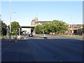
1
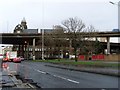
The M8 crosses Paisley Road West
Just after the Kingston Bridge, south of the River Clyde.
Image: © Stephen Sweeney
Taken: 18 Dec 2008
0.02 miles
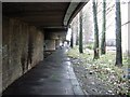
2
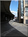
Carnoustie Street
In the shadow of the M8 motorway overhead.
Image: © Richard Sutcliffe
Taken: 19 Apr 2016
0.03 miles
3
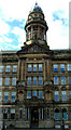
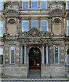
Former Scottish Cooperative Wholesale HQ
The main door on Morrison Street. The building was converted to flats in the late 1990s.
See also Image,
Image
& Image
Image: © Thomas Nugent
Taken: 18 Jul 2011
0.05 miles
4
Former Scottish Cooperative Wholesale HQ
Detail above the main door in Morrison Street. The building was converted to flats in the late 1990s.
See also
Image,
Image
& Image
Image: © Thomas Nugent
Taken: 18 Jul 2011
0.05 miles
5
Former Scottish Cooperative Wholesale HQ
Main door detail on Morrison Street. The building was converted to flats in the late 1990s.
See also Image,
Image
& Image
Image: © Thomas Nugent
Taken: 18 Jul 2011
0.05 miles
6
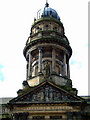
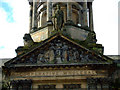
Former Scottish Cooperative Wholesale HQ
The 50 foot domed cupola above the main door on Morrison Street. The building was converted to flats in the late 1990s.
See also Image,
Image
& Image
Image: © Thomas Nugent
Taken: 18 Jul 2011
0.05 miles
7
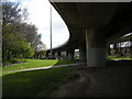
Under the motorway
Under the slip road off the M8 motorway at Junction 20. This is the first junction after the M8 crosses the Kingston Bridge over the River Clyde.
Image: © Richard Sutcliffe
Taken: 19 Apr 2016
0.06 miles
8
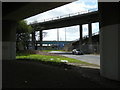
Under the motorways
The two nearest fly-overs are the slip roads off and onto the M8 at Junction 20. The fly-over in the distance is a section of the M74.
Image: © Richard Sutcliffe
Taken: 19 Apr 2016
0.06 miles
9
Path beneath motorway slipway
Beneath a slip road off the M8 in Kingston.
Image: © Stephen Sweeney
Taken: 18 Dec 2008
0.06 miles
10
Paisley Road (A8)
Looking towards the M8 motorway bridge
Image: © David Dixon
Taken: 17 Aug 2010
0.08 miles