IMAGES TAKEN NEAR TO
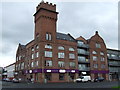
West Street, GLASGOW, G5 8BN
Introduction
This page details the photographs taken nearby to West Street, G5 8BN by members of the Geograph project.
The Geograph project started in 2005 with the aim of publishing, organising and preserving representative images for every square kilometre of Great Britain, Ireland and the Isle of Man.

There are currently over 7.5m images from over14,400 individuals and you can help contribute to the project by visiting https://www.geograph.org.uk
Image Map
Images are licensed for reuse under creativecommons.org/licenses/by-sa/2.0
Notes
- Clicking on the map will re-center to the selected point.
- The higher the marker number, the further away the image location is from the centre of the postcode.
Image Listing (270 Images Found)
Images are licensed for reuse under creativecommons.org/licenses/by-sa/2.0
Image
Details
Distance
1
Wallace Street
A converted building at the corner of West Street. The ground floor houses a design & planning company.
Image: © Thomas Nugent
Taken: 27 Aug 2008
0.01 miles
2
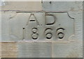
Date stone
On the Cook Street side of The Scottish Fashion Centre building Image
Image: © Thomas Nugent
Taken: 27 Aug 2008
0.01 miles
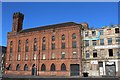
3
Former Victoria Grain Mills, corner of Wallace St & West St, Glasgow
Built 1894. Architect W F McGibbon. Converted for residential use in 2002.
Image: © Leslie Barrie
Taken: 27 Apr 2013
0.01 miles
4
Infiniti Computer Warehouse
In an old red brick building on Cook Street at Tradeston Street. Original use unknown.
Image: © Thomas Nugent
Taken: 27 Aug 2008
0.02 miles
5
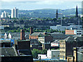
Glasgow rooftops
Tradeston, as seen from The Lighthouse. Note the derelict building, sprouting trees, just below the centre of the photo.
Image: © Thomas Nugent
Taken: 12 Aug 2013
0.04 miles
6
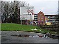
Road sign leaving M8 in Kingston
Just south of the Kingston Bridge.
Image: © Stephen Sweeney
Taken: 18 Dec 2008
0.04 miles
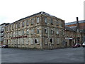
7
Former warehouse of Tradeston Paint Mills, Glasgow
On the corner of Tradeston Street and Cook Street
Image: © Leslie Barrie
Taken: 27 Apr 2013
0.04 miles
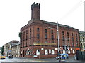
8
Scottish Fashion Centre
Housed in a restored building at the corner of Cook Street and West Street.
Image: © Thomas Nugent
Taken: 27 Aug 2008
0.05 miles
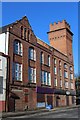
9
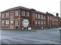
Wallace Street
What appears to be a former school at the corner of West Street.
Image: © Thomas Nugent
Taken: 27 Aug 2008
0.05 miles
10
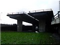
The "Ski Jump" or the "Road to Nowhere", Glasgow
An incomplete part of the Glasgow Inner Ring Road. Anyone looking at a map of Glasgow City Centre will see that the M8 boxes in the city on the west and north sides. This "box" was to be completed by a Ring Road on the east and south sides, but work on the ring road was abandoned in 1972, leaving several roads and bridges to nowhere around the city. This one in Kingston in the South Side was to connect up to the M74, which currently termninates at Carmyle. In 2008 work started on the extension of the M74, but it will now meet the M8 just south of this point. A proposal has been made for a bypass in the East End of the city, which will connect the M8 and M74 via Parkhead and to some extent complete the abandoned Inner City Ring Road.
Image: © Stephen Sweeney
Taken: 18 Dec 2008
0.06 miles