IMAGES TAKEN NEAR TO
Crookston Road, GLASGOW, G53 7TU
Introduction
This page details the photographs taken nearby to Crookston Road, G53 7TU by members of the Geograph project.
The Geograph project started in 2005 with the aim of publishing, organising and preserving representative images for every square kilometre of Great Britain, Ireland and the Isle of Man.

There are currently over 7.5m images from over14,400 individuals and you can help contribute to the project by visiting https://www.geograph.org.uk
Image Map
Images are licensed for reuse under creativecommons.org/licenses/by-sa/2.0
Notes
- Clicking on the map will re-center to the selected point.
- The higher the marker number, the further away the image location is from the centre of the postcode.
Image Listing (31 Images Found)
Images are licensed for reuse under creativecommons.org/licenses/by-sa/2.0
Image
Details
Distance

2
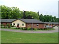
Buildings of Leverndale Hospital
The hospital's main tower can be seen in the background.
Image: © Stephen Sweeney
Taken: 25 May 2009
0.06 miles
3
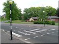
Zebra crossing
At Leverndale Hospital.
Image: © Stephen Sweeney
Taken: 25 May 2009
0.08 miles

5
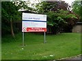
Sign at Leverndale Hospital
At the entrance off Crookston Road.
Image: © Stephen Sweeney
Taken: 25 May 2009
0.10 miles
6
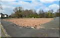
Former site of Howford Primary School
At the time this picture was taken, the building was still shown in online mapping, but, as I learned in an interesting chat with a woman passing by, a teenage girl was charged with wilful fire-raising after the building (by then out of use) burned down in July 2018. The site is adjacent to Crookston Road.
Image: © Lairich Rig
Taken: 11 Apr 2019
0.11 miles
7
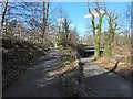
Cycle route at Howford Bridge
The cycle path leads under the bridge and then turns sharply, heading up the path on the left, to join the road over the bridge, as described at Image See Image for a view of the bridge from the other side.
Image: © Lairich Rig
Taken: 24 Mar 2014
0.13 miles
8

Building of Leverndale Hospital
Hidden behind the trees.
Image: © Stephen Sweeney
Taken: 25 May 2009
0.15 miles
9
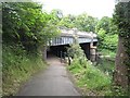
Howford Bridge
Crookston Road crossing the White Cart Water. A tight bend feeds the cycle path (National Cycle Route 75 and 7) in from Crookston Road to cross the road via a river side path.
Image: © Richard Webb
Taken: 16 Jun 2009
0.15 miles
10
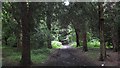
Path, Ross Hall Park
A riverside path running through dark woodlands in Rosshall Park. This was once the grounds of a large house.
Plenty of alternative spellings here, maps from 1898 have Ross Hill, and of course show it to be far out into rural Renfrewshire between Glasgow and Paisley. Glasgow has grown a lot in the last 100 years or so, often fragments of the grounds of country estates have survived as parks.
Image: © Richard Webb
Taken: 16 Jun 2009
0.15 miles