IMAGES TAKEN NEAR TO
Crookston Road, GLASGOW, G53 7DZ
Introduction
This page details the photographs taken nearby to Crookston Road, G53 7DZ by members of the Geograph project.
The Geograph project started in 2005 with the aim of publishing, organising and preserving representative images for every square kilometre of Great Britain, Ireland and the Isle of Man.

There are currently over 7.5m images from over14,400 individuals and you can help contribute to the project by visiting https://www.geograph.org.uk
Image Map
Images are licensed for reuse under creativecommons.org/licenses/by-sa/2.0
Notes
- Clicking on the map will re-center to the selected point.
- The higher the marker number, the further away the image location is from the centre of the postcode.
Image Listing (9 Images Found)
Images are licensed for reuse under creativecommons.org/licenses/by-sa/2.0
Image
Details
Distance
1

Shops on Barrhead Road
At Crookston Road.
Image: © Stephen Sweeney
Taken: 25 May 2009
0.07 miles

3
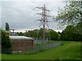
Electricity sub-station by Barrhead Road
At the head of Househill Park.
Image: © Stephen Sweeney
Taken: 25 May 2009
0.12 miles
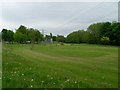
6
Househill Park
A long park beside the Levern Water.
Image: © Richard Webb
Taken: 25 Sep 2015
0.20 miles
7

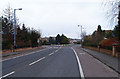
Dalmellington Road
From Crookston Road.
Image: © Stephen Sweeney
Taken: 25 May 2009
0.20 miles
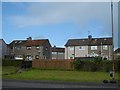
8
Road into Haughhill estate
Leading off the A736 Crookston Road.
Image: © wfmillar
Taken: 14 Mar 2012
0.21 miles
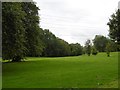
9
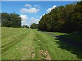
A path near the Levern Water
On the right, a narrow strip of woodland separates the path from the Levern Water. Barrhead Road is on the left, but is unseen because it is at the top of the grassy slope.
Image: © Lairich Rig
Taken: 26 Aug 2019
0.24 miles