IMAGES TAKEN NEAR TO
Calfhill Road, GLASGOW, G53 5YS
Introduction
This page details the photographs taken nearby to Calfhill Road, G53 5YS by members of the Geograph project.
The Geograph project started in 2005 with the aim of publishing, organising and preserving representative images for every square kilometre of Great Britain, Ireland and the Isle of Man.

There are currently over 7.5m images from over14,400 individuals and you can help contribute to the project by visiting https://www.geograph.org.uk
Image Map
Images are licensed for reuse under creativecommons.org/licenses/by-sa/2.0
Notes
- Clicking on the map will re-center to the selected point.
- The higher the marker number, the further away the image location is from the centre of the postcode.
Image Listing (47 Images Found)
Images are licensed for reuse under creativecommons.org/licenses/by-sa/2.0
Image
Details
Distance
1
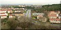
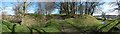
View from Crookston Castle - NNE
The viewpoint for this picture was the top of Crookston Castle, and the view is towards South Cardonald.
The main road that is prominent at the centre of the image is Lyoncross Road. The line of distant towerblocks to the right of centre is located at Moss Heights Avenue. The area of woodland filling the middle distance in the right-hand side of the image is Crookston Wood.
Image: © Lairich Rig
Taken: 9 Dec 2005
0.09 miles
2
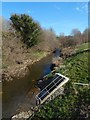
The Levern Water
The view is from the road bridge that carries Linthaugh Road over the river.
Image: © Lairich Rig
Taken: 24 Mar 2014
0.10 miles
3
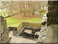
Position of causeway in Crookston Castle's ringworks
This picture was taken from an upper floor of Crookston Castle; see the main description: Image The existing ruined castle dates from the early fifteenth century, but the defensive earthworks were associated with an earlier (twelfth century) wooden structure that stood on the same site.
As was mentioned in the main description, the position of an original causeway in the defensive ringwork that surrounds the castle site can still be discerned today. The defensive ditch is clearly visible here, but note a path that crosses it near the position of the red van (which is parked in front of a nearby lodge). It is at this point, where the path crosses the ditch, that the original causeway would have been located.
In this image, on the near side of the ditch, just to the right of the path, it is just possible to make out something set into the grass. This is a plaque on a stone, and it reads:
"Gatehouse - This is where the gatehouse would always have stood. The first Crookston Castle was built by Robert Croc, who gave his name to the area, before 1180. You can still see the mighty bank and ditch which protected his timber hall, kitchen, bakehouse and stables. The stone castle was built by the Stewarts of Darnley around 1400. This is a carefully planned tower house, with a smaller symmetrical tower at each corner. The castle was damaged in a siege in 1489, and although partially rebuilt was in ruins by 1600."
Image: © Lairich Rig
Taken: 9 Dec 2005
0.14 miles
4
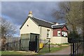
Cottage at entrance to Crookston Castle, Glasgow
Image: © Leslie Barrie
Taken: 27 Apr 2013
0.15 miles
5
Crookston Castle: defensive ditch
This wide-angle view, from the north-west, is intended to show the defensive earthworks. The deep ditch was a feature of Robert de Croc's original late-twelfth-century castle. The photograph also shows the causeway that led across the ditch.
Click on the end-note title for more pictures of the castle.
Image: © Lairich Rig
Taken: 24 Mar 2014
0.16 miles
6
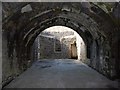
Crookston Castle: vaulted basement
This room, whose vaulting is apparent in the picture, would have been used for storage. The present-day entrance is at the extreme right-hand edge of the picture.
At the far end of the basement, on the left, is a blocked-up doorway to the (now demolished) south-west tower. On the right is another blocked doorway, which led to a kitchen in the (also now demolished) north-west tower. Food was sent up to the Great Hall by means of a dumb waiter system built within the thickness of the wall.
[The above information is from various panels on the walls of the basement.]
Image: © Lairich Rig
Taken: 24 Mar 2014
0.16 miles
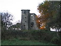
7
Crookston Castle
The north-eastern tower is on the right, with its fenced-off rooftop: Image On the left are the remains of the south-eastern tower; when this was intact, the castle would have had a more symmetrical appearance. For the intact north-east tower, see also Image
Click on the end-note title for related pictures.
The Image is in the left background.
Image: © Lairich Rig
Taken: 24 Mar 2014
0.16 miles
8
Crookston Castle: the rooftop
The rooftop is reached by means of the rungs shown in Image The square opening in that picture is the same one as shown here.
The prominent tower in the background is the Image
Image: © Lairich Rig
Taken: 24 Mar 2014
0.16 miles
9
Crookston Castle
In this view, the north-eastern tower, which survives to its full height, is at the back. The ruins of the south-eastern tower are on the right; compare Image
Click on the end-note title for related pictures.
Image: © Lairich Rig
Taken: 24 Mar 2014
0.16 miles
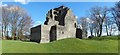
10
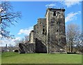
Crookston Castle
Crookston Castle, in the Pollok area of Glasgow, is an early 15th century construction. It is surrounded by a defensive ring ditch that dates back to the 12th century when Sir Robert Croc built an earlier castle and chapel. Crookston Castle sits on top of a natural hill and has four square corner towers. Only the north-east corner tower survives to its former height. Today, Crookston Castle is a Category A listed building. This view of the castle is from the north.
Image: © G Laird
Taken: 4 Nov 2013
0.16 miles