IMAGES TAKEN NEAR TO
Brockburn Road, GLASGOW, G53 5TJ
Introduction
This page details the photographs taken nearby to Brockburn Road, G53 5TJ by members of the Geograph project.
The Geograph project started in 2005 with the aim of publishing, organising and preserving representative images for every square kilometre of Great Britain, Ireland and the Isle of Man.

There are currently over 7.5m images from over14,400 individuals and you can help contribute to the project by visiting https://www.geograph.org.uk
Image Map
Images are licensed for reuse under creativecommons.org/licenses/by-sa/2.0
Notes
- Clicking on the map will re-center to the selected point.
- The higher the marker number, the further away the image location is from the centre of the postcode.
Image Listing (44 Images Found)
Images are licensed for reuse under creativecommons.org/licenses/by-sa/2.0
Image
Details
Distance
2
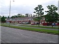
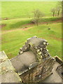
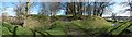
View from Crookston Castle - WSW
The viewpoint for this picture was the top of Crookston Castle.
The nearest houses at the left-hand edge of the image stand alongside Brockburn Road. The closest houses just right of centre, where a car is rounding a corner, are on Towerside Crescent.
The tower visible in the right-hand side of the image belongs to Leverndale Hospital, which was built in 1895, and was formerly known as Hawkhead Asylum. At the time of writing, Leverndale Hospital, which now includes more recent buildings, was still in use, and served as a psycho-geriatric unit.
The distant hills in the left of the image are the area around Gleniffer Braes.
Image: © Lairich Rig
Taken: 9 Dec 2005
0.08 miles
3
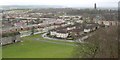
Linthaugh Road, Pollok
From Brockburn Road.
Image: © Stephen Sweeney
Taken: 25 May 2009
0.09 miles
4
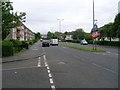
Path to Crookston Castle
From Towerside Crescent.
Image: © Stephen Sweeney
Taken: 25 May 2009
0.11 miles
5
Defensive ditch, from top of Crookston Castle
Visible in the upper half of this image is a small section of the defensive ringwork that surrounds Crookston Castle, as discussed in the main item, Image
Image: © Lairich Rig
Taken: 9 Dec 2005
0.14 miles
6
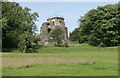
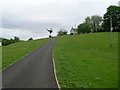
Crookston Castle
The castle faces onto Brockburn Road.
Image: © Richard Sutcliffe
Taken: 20 Jun 2014
0.15 miles
8
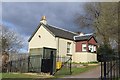
Cottage at entrance to Crookston Castle, Glasgow
Image: © Leslie Barrie
Taken: 27 Apr 2013
0.15 miles
9
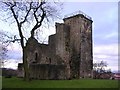
Crookston Castle: defensive ditch
This wide-angle view, from the north-west, is intended to show the defensive earthworks. The deep ditch was a feature of Robert de Croc's original late-twelfth-century castle. The photograph also shows the causeway that led across the ditch.
Click on the end-note title for more pictures of the castle.
Image: © Lairich Rig
Taken: 24 Mar 2014
0.16 miles
10
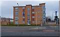
Apartments Leverndale Road
Lots of new build around this area.
Image: © wfmillar
Taken: 14 Mar 2012
0.16 miles