IMAGES TAKEN NEAR TO
Glenside Avenue, GLASGOW, G53 5SD
Introduction
This page details the photographs taken nearby to Glenside Avenue, G53 5SD by members of the Geograph project.
The Geograph project started in 2005 with the aim of publishing, organising and preserving representative images for every square kilometre of Great Britain, Ireland and the Isle of Man.

There are currently over 7.5m images from over14,400 individuals and you can help contribute to the project by visiting https://www.geograph.org.uk
Image Map
Images are licensed for reuse under creativecommons.org/licenses/by-sa/2.0
Notes
- Clicking on the map will re-center to the selected point.
- The higher the marker number, the further away the image location is from the centre of the postcode.
Image Listing (37 Images Found)
Images are licensed for reuse under creativecommons.org/licenses/by-sa/2.0
Image
Details
Distance
1
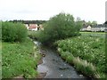
Levern Water
From the footbridge in Pollok.
Image: © Stephen Sweeney
Taken: 25 May 2009
0.05 miles
2
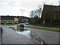
Lyoncross Road, Pollok
This corner always had a puddle when it rained, it may have a drain now.
Image: © Stevie Spiers
Taken: 20 Jan 2005
0.08 miles
3
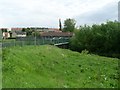
Footbridge over Levern Water
In Pollok, connecting Brockburn Road with Braidcraft Road.
Image: © Stephen Sweeney
Taken: 25 May 2009
0.09 miles
4
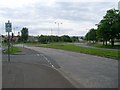
Approaching the roundabout on Brockburn Road
In Pollok, just to the west of the Levern Water.
Image: © Stephen Sweeney
Taken: 25 May 2009
0.09 miles
5
Pollok
Looking to Lyoncross Road from beside the footbridge over the Levern Water.
Image: © Stephen Sweeney
Taken: 25 May 2009
0.15 miles
6
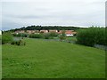
View from Crookston Castle - ENE
The viewpoint for this picture was the top of Crookston Castle, and the view is towards the Pollok and Corkerhill areas of Glasgow.
The main road visible at the bottom of the image is Lyoncross Road; between this road and the unseen Potterhill Road (higher up the slope) are two rows of houses. Between Potterhill Road and Barnbeth Road (higher up again) are another two rows of houses. There are no houses on the far side of Barnbeth Road, but Crookston Wood begins there; this wood can be seen in the photo.
Image: © Lairich Rig
Taken: 9 Dec 2005
0.16 miles
7
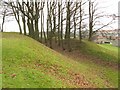
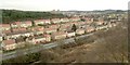
Defensive ditch of Crookston Castle
See the main item, Image, which discusses this defensive ringwork.
The two closest houses visible in this photo stand on the near side of Brockburn Road, while the remainder of the houses are on its other side.
Image: © Lairich Rig
Taken: 9 Dec 2005
0.18 miles
8
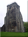
The NE tower of Crookston Castle
This tower is the only part of the castle which still survives to its original height.
Image: © Stephen Sweeney
Taken: 13 May 2010
0.19 miles
9
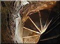
Crookston Castle: spiral staircase
From the Great Hall (Image), the spiral staircase gives access to the Lord's Bedchamber (Image).
Beside the same staircase are the remains of a medieval latrine, and a blocked door to the (now largely demolished) south-eastern tower (see Image, where the remains of that tower are on the left). Further up, the staircase is blocked, but it would have given access to the uppermost rooms in the north-eastern tower (i.e., the two storeys of rooms directly above the Lord's Bedchamber). Those rooms are now reached, instead, by sets of modern metal rungs.
Image: © Lairich Rig
Taken: 24 Mar 2014
0.20 miles
10
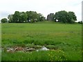
Marsh land and Crookston Castle
Marshy area at the foot of the hill at Crookston Castle.
Image: © Stephen Sweeney
Taken: 25 May 2009
0.20 miles