IMAGES TAKEN NEAR TO
Cronberry Quadrant, GLASGOW, G52 3NU
Introduction
This page details the photographs taken nearby to Cronberry Quadrant, G52 3NU by members of the Geograph project.
The Geograph project started in 2005 with the aim of publishing, organising and preserving representative images for every square kilometre of Great Britain, Ireland and the Isle of Man.

There are currently over 7.5m images from over14,400 individuals and you can help contribute to the project by visiting https://www.geograph.org.uk
Image Map
Images are licensed for reuse under creativecommons.org/licenses/by-sa/2.0
Notes
- Clicking on the map will re-center to the selected point.
- The higher the marker number, the further away the image location is from the centre of the postcode.
Image Listing (25 Images Found)
Images are licensed for reuse under creativecommons.org/licenses/by-sa/2.0
Image
Details
Distance
1
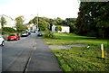
Cairnhill Circus
Residential street and green space.
Image: © Richard Sutcliffe
Taken: 12 Sep 2018
0.11 miles
2
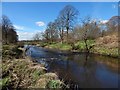
White Cart Water
The view is from a little off the cycle route, about 200 metres west of the Howford Bridge.
Image: © Lairich Rig
Taken: 24 Mar 2014
0.11 miles
3
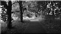
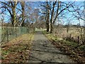
Riverside path, White Cart Water
National Cycle Route 7 and 75 use this well surfaced path running between a hay meadow and the vicious spiked railings that once protected the river. Plenty of gaps in the fence now.
Image: © Richard Webb
Taken: 16 Jun 2009
0.11 miles
4
Green space beside Cairnhill Circus
Image: © Richard Sutcliffe
Taken: 12 Sep 2018
0.12 miles
5
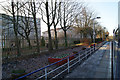
Cycle route at Rosshall
Behind the fence on the left, a narrow strip of woodland separates the cycle route from the Image
Image: © Lairich Rig
Taken: 24 Mar 2014
0.13 miles
6
Crookston railway station
On the recently electrified paisley Canal line.
Image: © Thomas Nugent
Taken: 1 Dec 2012
0.15 miles
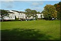
7
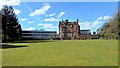
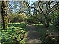
Ross Hall Hospital
This view over the main lawn of the Rosshall Estate is from beside a pond: Image
Image: © Lairich Rig
Taken: 24 Mar 2014
0.18 miles
8
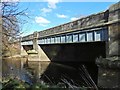
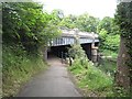
Howford Bridge
The bridge carries Crookston Road over the White Cart Water. At or near this spot, John Ainslie's 1796 map — https://maps.nls.uk/view/74400319 (at NLS) — of Renfrewshire shows "Howford Bridge", a predecessor of the one shown in my picture.
Image: © Lairich Rig
Taken: 24 Mar 2014
0.19 miles
9
Howford Bridge
Crookston Road crossing the White Cart Water. A tight bend feeds the cycle path (National Cycle Route 75 and 7) in from Crookston Road to cross the road via a river side path.
Image: © Richard Webb
Taken: 16 Jun 2009
0.21 miles
10
Rosshall Gardens
See http://www.geograph.org.uk/tagged/Rosshall+Park#photo=3947699 for more views of Rosshall Park and Gardens.
Image: © Lairich Rig
Taken: 24 Mar 2014
0.21 miles