IMAGES TAKEN NEAR TO
Talla Road, GLASGOW, G52 2AY
Introduction
This page details the photographs taken nearby to Talla Road, G52 2AY by members of the Geograph project.
The Geograph project started in 2005 with the aim of publishing, organising and preserving representative images for every square kilometre of Great Britain, Ireland and the Isle of Man.

There are currently over 7.5m images from over14,400 individuals and you can help contribute to the project by visiting https://www.geograph.org.uk
Image Map
Images are licensed for reuse under creativecommons.org/licenses/by-sa/2.0
Notes
- Clicking on the map will re-center to the selected point.
- The higher the marker number, the further away the image location is from the centre of the postcode.
Image Listing (9 Images Found)
Images are licensed for reuse under creativecommons.org/licenses/by-sa/2.0
Image
Details
Distance
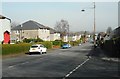
2
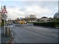
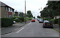
Hillington Road South
Looking towards the mini roundabout at the junction with Thurston Road.
Image: © Stephen Sweeney
Taken: 4 Mar 2009
0.15 miles
3
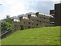
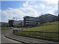
Chirnside Place
Stepped flats with deck access built on a hillside. There are six blocks set in parkland.
Image: © Richard Webb
Taken: 16 Jun 2009
0.17 miles
4
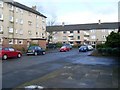
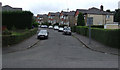
Hillington Quadrant
Housing estate in the area of the same name - Hillington.
Image: © Stephen Sweeney
Taken: 4 Mar 2009
0.17 miles
5
Chirnside Place
The flats have changed their appearance since 2009. Image
Image: © Richard Webb
Taken: 9 Apr 2013
0.19 miles
6
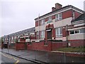
Chirnside Road
Looking west from outside Hillington East railway station.
Image: © Thomas Nugent
Taken: 4 Sep 2010
0.21 miles
7
Reston Drive
Off Chirnside Road at Hillington East railway station.
Image: © Thomas Nugent
Taken: 4 Sep 2010
0.23 miles
8
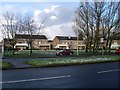
Sandwood Road houses
Looking across from Hillington Terrace.
Image: © Stephen Sweeney
Taken: 4 Mar 2009
0.23 miles
9
Tweedsmuir Road
Looking from the junction with Swinton Drive.
Image: © Richard Sutcliffe
Taken: 24 Mar 2017
0.24 miles