IMAGES TAKEN NEAR TO
Barnwell Terrace, GLASGOW, G51 4TP
Introduction
This page details the photographs taken nearby to Barnwell Terrace, G51 4TP by members of the Geograph project.
The Geograph project started in 2005 with the aim of publishing, organising and preserving representative images for every square kilometre of Great Britain, Ireland and the Isle of Man.

There are currently over 7.5m images from over14,400 individuals and you can help contribute to the project by visiting https://www.geograph.org.uk
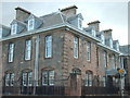
Image Map
Images are licensed for reuse under creativecommons.org/licenses/by-sa/2.0
Notes
- Clicking on the map will re-center to the selected point.
- The higher the marker number, the further away the image location is from the centre of the postcode.
Image Listing (18 Images Found)
Images are licensed for reuse under creativecommons.org/licenses/by-sa/2.0
Image
Details
Distance
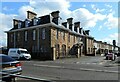
3
House on Langlands Road
A detached, red sandstone villa on Langlands Road.
Image: © Richard Sutcliffe
Taken: 30 Mar 2022
0.15 miles
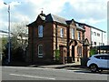
4

Victory Christian Centre
Relatively new building on the site of the former Victory Centre. I believe the old building was destroyed by fire and had to be demolished.
Image: © Lynn M Reid
Taken: 22 Mar 2008
0.15 miles
5
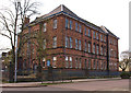
Greenfield Public School, Govan
Another fine red sandstone building in decline.
Image: © wfmillar
Taken: 15 Apr 2011
0.16 miles
6
Elder Cottage Hospital
A category A listed former hospital http://portal.historicenvironment.scot/designation/LB33300, on Drumoyne Drive and Langlands Road, by Sir John James Burnet, opened in 1905. It was built by and dedicated to Isabella Elder. The hospital closed in 1987.
Image: © Richard Sutcliffe
Taken: 30 Mar 2022
0.16 miles
7
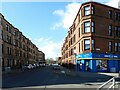
Crossloan Road
One-O-one on the corner is a licensed convenience store.
Image: © Richard Sutcliffe
Taken: 30 Mar 2022
0.19 miles
8
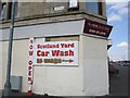
Street corner, Luss Road
Appears to be a bricked up shop.
Image: © Richard Webb
Taken: 9 Apr 2013
0.20 miles
9
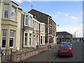
Luss Road
The site was shown as agricultural land on the first edition 6" map (mid 19th century) and by 1890 was an industrial area.
Image: © Richard Webb
Taken: 9 Apr 2013
0.20 miles
10

Statue of Isabella Elder
The seated bronze statue of Isabella Elder, titled 'MRS JOHN ELDER, LL.D.', by Archibald McFarlane Shannan, RSA was unveiled in 1906. It is Category A listed http://portal.historicenvironment.scot/designation/LB33304.
Image: © Richard Sutcliffe
Taken: 30 Mar 2022
0.21 miles