IMAGES TAKEN NEAR TO
Row Avenue, GLASGOW, G51 4SY
Introduction
This page details the photographs taken nearby to Row Avenue, G51 4SY by members of the Geograph project.
The Geograph project started in 2005 with the aim of publishing, organising and preserving representative images for every square kilometre of Great Britain, Ireland and the Isle of Man.

There are currently over 7.5m images from over14,400 individuals and you can help contribute to the project by visiting https://www.geograph.org.uk
Image Map
Images are licensed for reuse under creativecommons.org/licenses/by-sa/2.0
Notes
- Clicking on the map will re-center to the selected point.
- The higher the marker number, the further away the image location is from the centre of the postcode.
Image Listing (40 Images Found)
Images are licensed for reuse under creativecommons.org/licenses/by-sa/2.0
Image
Details
Distance
2
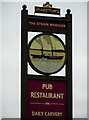
Sign for the Steam Wheeler
Public and restaurant Image
Image: © Richard Sutcliffe
Taken: 16 Mar 2022
0.08 miles
3
The Steam Wheeler
Pub and restaurant at the corner of Row Avenue and King's Inch Drive.
Image: © Richard Sutcliffe
Taken: 16 Mar 2022
0.08 miles
4
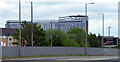
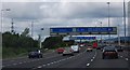
Queen Elizabeth University Hospital
Viewed from the M8 motorway, eastbound at Junction 26. Note the air ambulance helicopter on the roof.
See also Image & Image
Image: © Thomas Nugent
Taken: 5 May 2019
0.09 miles
5

Queen Elizabeth University Hospital
Viewed from the M8 motorway, eastbound at Junction 26. Note the air ambulance helicopter on the roof.
See also Image & Image
Image: © Thomas Nugent
Taken: 5 May 2019
0.09 miles
6
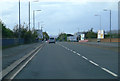
The A8 Renfrew Road
This was the main road from Glasgow city centre to the former Glasgow Airport at Renfrew. The M8 is just behind the bushes on the left and it leads to the present Glasgow Airport at Abbotsinch. The parapet of a bridge over the railway line to Kings Inch can be seen beside the cones on the right and the road sign on the left. This line once ran all the way to Renfrew, but now stops a few hundred metres to the right of the bridge.
Image: © Thomas Nugent
Taken: 16 Oct 2011
0.09 miles
7
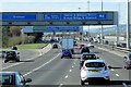
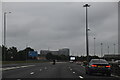
M8, Junction 25A
A typical “Glasgow-type” sign gantry at Junction 25A of the M8, with the following distinctive elements:
• near and offside support legs (basically 2 rectangular hollow sections with base plates to allow connections to the foundations),
• a Main Frame (made up of rectangular hollow sections) - Over clad on the front and rear,
• a Sub Frame (made up of smaller hollow sections and welded to main frame),
• a Sign Face - acrylic sheets hung from the front of the sub frame over its full height,
• internal Electrics - sign lighting provided through the use of several dozen fluorescent battens.
Gantries of this type were first erected as part of the construction of the Kingston Bridge and its approach roads in 1970 and they are now a familiar sight on the network around Glasgow.
More information on “Glasgow Style Gantries” at http://www.glasgows-motorways.co.uk/glasgow-gantries/4578281645 (Glasgow’s Motorways)
Image: © David Dixon
Taken: 24 Mar 2014
0.09 miles
8
M8 and A8, side by side
Motorway and main road between Braehead and Shieldhall.
Image: © Stephen Sweeney
Taken: 16 Aug 2007
0.10 miles
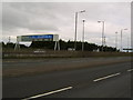
10
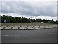
Kings Inch Drive Roundabout
At the entrance to Dobbies garden centre.
Image: © Billy McCrorie
Taken: 14 Aug 2012
0.11 miles