IMAGES TAKEN NEAR TO
Aboukir Street, GLASGOW, G51 4QX
Introduction
This page details the photographs taken nearby to Aboukir Street, G51 4QX by members of the Geograph project.
The Geograph project started in 2005 with the aim of publishing, organising and preserving representative images for every square kilometre of Great Britain, Ireland and the Isle of Man.

There are currently over 7.5m images from over14,400 individuals and you can help contribute to the project by visiting https://www.geograph.org.uk
Image Map
Images are licensed for reuse under creativecommons.org/licenses/by-sa/2.0
Notes
- Clicking on the map will re-center to the selected point.
- The higher the marker number, the further away the image location is from the centre of the postcode.
Image Listing (92 Images Found)
Images are licensed for reuse under creativecommons.org/licenses/by-sa/2.0
Image
Details
Distance
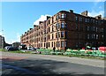
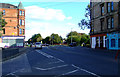
1
Corner of Aboukir Street & Govan Road, Glasgow
Image: © Leslie Barrie
Taken: 9 Jul 2013
0.02 miles
2
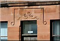
Building detail
Finely carved detail above the door of one of the tenements on Govan Road Image
Image: © Richard Sutcliffe
Taken: 30 Mar 2022
0.03 miles
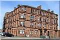
3
Tenement block, Govan Road
A fine red sandstone tenement block at the corner with Aboukir Street on the right. The barriers relate to some work involving pipes or cables being undertaken outside.
Image: © Richard Sutcliffe
Taken: 30 Mar 2022
0.03 miles
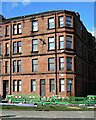
4
Tenement block, Govan Road
A fine red sandstone tenement block at the corner with Aboukir Street on the right. Some work involving pipes or cables is being undertaken outside.
Image: © Richard Sutcliffe
Taken: 30 Mar 2022
0.03 miles
5
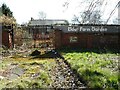
Elder Farm Garden
The rear of the Category B listed http://portal.historicenvironment.scot/designation/LB33302 cottage in Elder Park. It is in very poor condition and in the Buildings at Risk Register https://buildingsatrisk.org.uk/search/keyword/govan/event_id/904391/building_name/fairfield-farm-govan. For many years the building was used by the Council's Parks Department, but after a re-organisation staff were transferred to other locations and the building lay empty and in due course was vandalised. In 2012-13 the Elder Farm Community took over the grounds around the building as a community garden, but the site is derelict again.
Image: © Richard Sutcliffe
Taken: 30 Mar 2022
0.04 miles
6
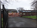
Elder Farm Garden
Community garden in Govan.
Image: © Barbara Carr
Taken: 22 Apr 2013
0.05 miles
7
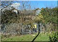
Cottage, Elder Park
A Category B listed building http://portal.historicenvironment.scot/designation/LB33302, but in very poor condition and in the Buildings at Risk Register https://buildingsatrisk.org.uk/search/keyword/govan/event_id/904391/building_name/fairfield-farm-govan. Presumed to be a farmhouse originally and dating from the early 19th century. For many years the building was used by the Council's Parks Department, but after a re-organisation staff were transferred to other locations and the building lay empty and in due course was vandalised.
When photographed in 2013 Image there had been proposals for a restoration, but this has not happened.
Image: © Richard Sutcliffe
Taken: 30 Mar 2022
0.06 miles
8

Fairfield Farm, Elder Park, Glasgow
Built c1850. After having lain derelict for some years, plans are now in place which should lead to restoration and a new use found for the farmhouse.
Image: © Leslie Barrie
Taken: 9 Jul 2013
0.06 miles
10
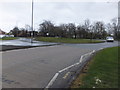
Linthouse
At the local exit sliproad from the southbound Clyde Tunnel.
Image: © Thomas Nugent
Taken: 25 Sep 2010
0.06 miles