IMAGES TAKEN NEAR TO
Meldon Place, GLASGOW, G51 4PB
Introduction
This page details the photographs taken nearby to Meldon Place, G51 4PB by members of the Geograph project.
The Geograph project started in 2005 with the aim of publishing, organising and preserving representative images for every square kilometre of Great Britain, Ireland and the Isle of Man.

There are currently over 7.5m images from over14,400 individuals and you can help contribute to the project by visiting https://www.geograph.org.uk
Image Map (32 Images)

Leaflet Map data © OpenStreetMap
Images are licensed for reuse under creativecommons.org/licenses/by-sa/2.0
Notes
- Clicking on the map will re-center to the selected point.
- The higher the marker number, the further away the image location is from the centre of the postcode.
Image Listing (32 Images Found)
Images are licensed for reuse under creativecommons.org/licenses/by-sa/2.0
Image
Details
Distance
1
Alley off Holmfauldhead Drive
Leading to the rear of the properties on the left.
Image: © Richard Sutcliffe
Taken: 13 Nov 2018
0.11 miles
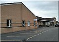
3
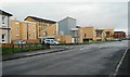
Properties on Holmfauldhead Drive
Modern designs contrast with the traditional tenements behind.
Image: © Richard Sutcliffe
Taken: 13 Nov 2018
0.14 miles
4
St Kenneth Drive, Linthouse
Looking towards the Southern General Hospital clock tower.
Image: © Lynn M Reid
Taken: 22 Mar 2008
0.14 miles
5
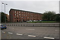
Tenement, Burghead Drive
Looking across the A739 just south of the Clyde Tunnel towards the tenements on Burghead Drive.
Image: © Richard Sutcliffe
Taken: 28 Aug 2015
0.17 miles
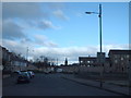
6
The A739 just south of the Clyde Tunnel
Image: © Richard Sutcliffe
Taken: 13 Nov 2018
0.18 miles
7
Queen Elizabeth National Spinal Injuries Unit
Part of the Queen Elizabeth University Hospital campus. The Unit is responsible for the acute and lifelong care of all adult patients in Scotland with traumatic and non-progressive spinal cord injury.
Image: © Richard Sutcliffe
Taken: 26 Apr 2021
0.18 miles
8
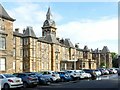
Former Govan Combination Parochial Buildings poorhouse
The buildings were on a large scale incorporating Poorhouse, Asylum and Hospital, opened in 1872, designed by James Thomson.
This was the main poorhouse block. The complex became the Southern General Hospital in 1923, this block eventually housing the administration section, a function it still performs as part of the Queen Elizabeth University Hospital. It represents one of the few survivors nationally of large scale poorhouses developed in the latter part of the 19th century. Listed Category B http://portal.historicenvironment.scot/designation/LB33306
Image: © Alan Murray-Rust
Taken: 25 Jun 2019
0.19 miles
9
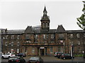
Clock Tower - Southern General Hospital
Above the main entrance of one of the main buildings of the hospital, which is undergoing redevelopment, part of which can be seen above the ridge to the left, and also at Image
Image: © M J Richardson
Taken: 4 May 2014
0.19 miles
10
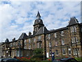
Clock Tower Southern General Hospital
Image: © John Ferguson
Taken: 16 Jul 2009
0.19 miles