IMAGES TAKEN NEAR TO
Greenfield Street, GLASGOW, G51 3PW
Introduction
This page details the photographs taken nearby to Greenfield Street, G51 3PW by members of the Geograph project.
The Geograph project started in 2005 with the aim of publishing, organising and preserving representative images for every square kilometre of Great Britain, Ireland and the Isle of Man.

There are currently over 7.5m images from over14,400 individuals and you can help contribute to the project by visiting https://www.geograph.org.uk
Image Map
Images are licensed for reuse under creativecommons.org/licenses/by-sa/2.0
Notes
- Clicking on the map will re-center to the selected point.
- The higher the marker number, the further away the image location is from the centre of the postcode.
Image Listing (82 Images Found)
Images are licensed for reuse under creativecommons.org/licenses/by-sa/2.0
Image
Details
Distance
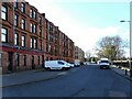
1
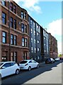
Tenements, Elderpark Street
The modern tenement in the middle marks the site of the former Congregational church which used to occupy the site. It was demolished in 2008. See Canmore https://canmore.org.uk/site/294145/glasgow-elderpark-street-congregational-church.
Image: © Richard Sutcliffe
Taken: 30 Mar 2022
0.06 miles
3
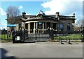
Elder Park Library
Category A listed library http://portal.historicenvironment.scot/designation/LB33310 by Sir John James Burnet, 1902-3.
The library is currently closed, but there are plans by Glasgow Life who run libraries on behalf of Glasgow City Council, to renovate the building to include a cafe and community centre space, in addition to providing library services.
Image: © Richard Sutcliffe
Taken: 30 Mar 2022
0.09 miles
4
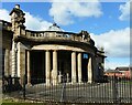
Elder Park Library
Category A listed library http://portal.historicenvironment.scot/designation/LB33310 by Sir John James Burnet, 1902-3.
The library is currently closed, but there are plans by Glasgow Life who run libraries on behalf of Glasgow City Council, to renovate the building to include a cafe and community centre space, in addition to providing library services.
Image: © Richard Sutcliffe
Taken: 30 Mar 2022
0.09 miles
5
Langlands Road
The sandstone tenements overlook Elder Park and Elder Park Library.
Image: © Richard Sutcliffe
Taken: 30 Mar 2022
0.10 miles
6
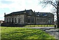
Elder Park Library
Category A listed library http://portal.historicenvironment.scot/designation/LB33310 by Sir John James Burnet, 1902-3.
The library is currently closed, but there are plans by Glasgow Life who run libraries on behalf of Glasgow City Council, to renovate the building to include a cafe and community centre space, in addition to providing library services.
Image: © Richard Sutcliffe
Taken: 30 Mar 2022
0.10 miles
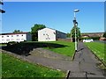
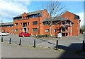
8
Elder Street
Modern residential properties.
Image: © Richard Sutcliffe
Taken: 30 Mar 2022
0.11 miles
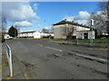
9
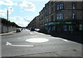
Roundabout, Crossloan Road
Looking down Craigton Road.
Image: © Richard Sutcliffe
Taken: 30 Mar 2022
0.13 miles
10
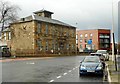
Former Hill's Trust School, Govan
The Category B listed school http://portal.historicenvironment.scot/designation/LB33339 on Golspie Street dates from 1874.
According to the Buildings at Risk Register https://www.buildingsatrisk.org.uk/details/966773, Elderpark Housing Association are currently developing the site as their new headquarters.
Image: © Richard Sutcliffe
Taken: 20 Feb 2020
0.13 miles