IMAGES TAKEN NEAR TO
Summertown Path, GLASGOW, G51 2FB
Introduction
This page details the photographs taken nearby to Summertown Path, G51 2FB by members of the Geograph project.
The Geograph project started in 2005 with the aim of publishing, organising and preserving representative images for every square kilometre of Great Britain, Ireland and the Isle of Man.

There are currently over 7.5m images from over14,400 individuals and you can help contribute to the project by visiting https://www.geograph.org.uk
Image Map
Images are licensed for reuse under creativecommons.org/licenses/by-sa/2.0
Notes
- Clicking on the map will re-center to the selected point.
- The higher the marker number, the further away the image location is from the centre of the postcode.
Image Listing (114 Images Found)
Images are licensed for reuse under creativecommons.org/licenses/by-sa/2.0
Image
Details
Distance
1
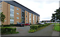
Summertown Path
Off Summertown Street.
Image: © Thomas Nugent
Taken: 27 Aug 2018
0.01 miles
2
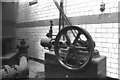
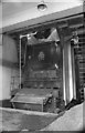
Ibrox Baths, steam engine
Engine of unknown make that was used in conjunction with a set of Bell Bros patent pressure filters (part of one is seen on the left). Tiny engine with a slide valve cylinder 3.5" x 6" and a 2' flywheel. The Baths are gone and the engine's fate is unknown.
Image: © Chris Allen
Taken: 26 Apr 1982
0.02 miles
3
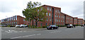
Summertown Road
Dunsmuir Street is on the left.
Image: © Thomas Nugent
Taken: 27 Aug 2018
0.03 miles
4
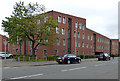
Summertown Road
Dunsmuir Street is on the left.
Image: © Thomas Nugent
Taken: 27 Aug 2018
0.03 miles
5
Ibrox Baths, boiler
A 1958 built Babcock and Wilcox water tube boiler with mechanical stoker burning coal. An absolute gem that was still in steam in 1982 and could be seen from the street.
Image: © Chris Allen
Taken: 26 Apr 1982
0.03 miles
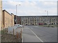
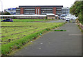
6
Kintra Street
An area undergoing redevelopment with new houses on the north side. To the south there is a large area of grassland where the previous houses have been demolished. The tenements are on Briton Street.Maps show this remained open land long after much of industrial Govan was built and three oval residential blocks built sometime in the 20th century.
Image: © Richard Webb
Taken: 9 Apr 2013
0.03 miles
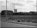
7
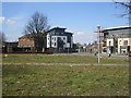
Small park, Summertown Road
A small open space which looks much bigger at the moment as several streets between here and Ibrox Stadium (behind me) have been demolished. Nearby high rise blocks are being demolished.
Maps show this remained open land long after much of industrial Govan was built and three oval residential blocks built sometime in the 20th century.
Image: © Richard Webb
Taken: 9 Apr 2013
0.04 miles
8
Kintra Street
Looking towards Ibrox Stadium from Summertown Road. Columba Street is behind the big tree.
Image: © Thomas Nugent
Taken: 27 Aug 2018
0.04 miles
9
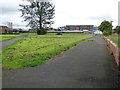
Iona Street
A razed residential area near Ibrox Stadium. The streets remain but there are no buildings. Useful for driving schools.
Maps show this remained open land long after much of industrial Govan was built and three oval residential blocks built sometime in the 20th century.
Image: © Richard Webb
Taken: 9 Apr 2013
0.04 miles
10
Kintra Street
Looking towards Ibrox Stadium from Summertown Road.
Image: © Thomas Nugent
Taken: 27 Aug 2018
0.05 miles