IMAGES TAKEN NEAR TO
Vicarfield Street, GLASGOW, G51 2DB
Introduction
This page details the photographs taken nearby to Vicarfield Street, G51 2DB by members of the Geograph project.
The Geograph project started in 2005 with the aim of publishing, organising and preserving representative images for every square kilometre of Great Britain, Ireland and the Isle of Man.

There are currently over 7.5m images from over14,400 individuals and you can help contribute to the project by visiting https://www.geograph.org.uk
Image Map
Images are licensed for reuse under creativecommons.org/licenses/by-sa/2.0
Notes
- Clicking on the map will re-center to the selected point.
- The higher the marker number, the further away the image location is from the centre of the postcode.
Image Listing (211 Images Found)
Images are licensed for reuse under creativecommons.org/licenses/by-sa/2.0
Image
Details
Distance
1

Highway Maintenance truck
A shiny yellow DAF Truck for cleaning drains on Orkney Street.
Image: © Richard Sutcliffe
Taken: 3 May 2022
0.03 miles
2
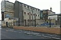
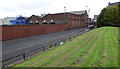
Former Govan Police Building and Govan Municipal Buildings
See the same scene in November 2018, before the boundary wall was rebuilt Image
Image: © Thomas Nugent
Taken: 16 Dec 2021
0.05 miles
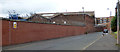
3
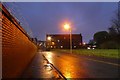
Broomloan Road
Behind the wall is the Glasgow Subway Depot.
Image: © DS Pugh
Taken: 6 Apr 2019
0.06 miles
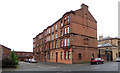
4
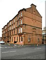
Tenement block, Orkney Place
There is a date stone of 1898 and the inscription A.B.A. on the gable facing Orkney Street.
Image: © Richard Sutcliffe
Taken: 3 May 2022
0.06 miles
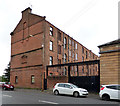
5
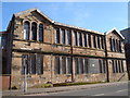
Derelict school buildings, Broomloan Road, Govan
Image: © David McMumm
Taken: 2 Mar 2010
0.07 miles
6
Glasgow Subway depot
The Broomloan Road side of the depot.
Image: © Thomas Nugent
Taken: 27 Aug 2018
0.07 miles
7
Broomloan Road
The north end of the road, with the Glasgow Subway depot on the left.
Image: © Thomas Nugent
Taken: 27 Aug 2018
0.07 miles
8
Orkney Street
Formerly named Albert Street. The black gate led to the yard of the former Govan fire station https://www.theglasgowstory.com/image/?inum=TGSE00752 which was located on the ground floor of the tenement which can be seen. The tenement is on Orkney Place, which was formerly known as Russell Street. The old fire station closed in 1987, having been replaced with a new one nearby Image
Image: © Thomas Nugent
Taken: 27 Aug 2018
0.07 miles
9
Orkney Place
Formerly named Russell Street. The black gate led to the yard of the former Govan fire station https://www.theglasgowstory.com/image/?inum=TGSE00752 which was located in the nearest corner of the ground floor of the tenement. The difference in colour of the building fabric and different window configuration from the rest of the ground floor reveals the location of the old fire station, which closed in 1987, having been replaced with a new one nearby Image
Image: © Thomas Nugent
Taken: 27 Aug 2018
0.07 miles
10
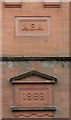
Date stone at Orkney Place
1898 date stone on the Orkney Street side of the Orkney Place tenement Image which was formerly home to Govan fire station. Information about the A.B.A. inscription is welcome.
Image: © Thomas Nugent
Taken: 27 Aug 2018
0.07 miles