IMAGES TAKEN NEAR TO
Marine Gardens, GLASGOW, G51 1HH
Introduction
This page details the photographs taken nearby to Marine Gardens, G51 1HH by members of the Geograph project.
The Geograph project started in 2005 with the aim of publishing, organising and preserving representative images for every square kilometre of Great Britain, Ireland and the Isle of Man.

There are currently over 7.5m images from over14,400 individuals and you can help contribute to the project by visiting https://www.geograph.org.uk
Image Map
Images are licensed for reuse under creativecommons.org/licenses/by-sa/2.0
Notes
- Clicking on the map will re-center to the selected point.
- The higher the marker number, the further away the image location is from the centre of the postcode.
Image Listing (179 Images Found)
Images are licensed for reuse under creativecommons.org/licenses/by-sa/2.0
Image
Details
Distance
1
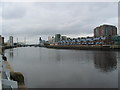
Springfield Quay view of the River Clyde, Glasgow.
Image: © Johnny Durnan
Taken: 22 Jan 2006
0.01 miles
3
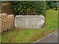
Princes Dock Commemorative Stone
Located on the grass verge of Mavisbank Gardens the stone is inscribed with the details of a new dock completed in 1896. It is likely referring to Princes Dock which was located west of the location and was originally known as Cessnock Dock but renamed Princes Dock in honour of the Duke of York who opened the docks in 1897. Continuing the maritime theme a large anchor sits further back on the grass.
Image: © Gordon Dowie
Taken: 19 Apr 2010
0.03 miles
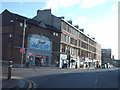
4
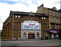
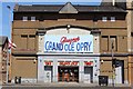
Glasgow's Grand Ole Opry
The largest Country and Western bar in the UK, situated on Paisley Road West.
Image: © Stephen Sweeney
Taken: 18 Dec 2008
0.03 miles
6
Former tollroad
Surveyed by the Milestone Society. The post is at the Workspace Housing Site at the junction of Paisley Road West and Govan Road. It denotes the old turnpike roads from Glasgow to Greenock via Paisley and Govan. The premises on the extreme left are called 'The Toll Bar'.
Image: © Diana Burns
Taken: 12 Oct 2013
0.04 miles
7
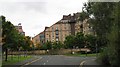
Mavisbank Gardens
Ziggurat overlooking the Clyde. One of several flat developments beside the water
Image: © Richard Webb
Taken: 24 Sep 2008
0.04 miles
8
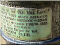
Former tollroad
Surveyed by the Milestone Society. Another view of the post/bollard for the Parkhouse Tollroad at the junction of Paisley Road West and Govan Road showing the rest of the legend.
Image: © Diana Burns
Taken: 12 Oct 2013
0.04 miles
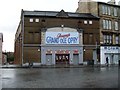
9
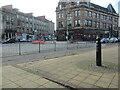
Glasgow's Grand Ole Opry
Popular venue on Paisley Road Toll
Image: © Leslie Barrie
Taken: 9 Jul 2013
0.05 miles
10
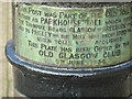
Former tollroad
Surveyed by the Milestone Society. A close up of the post/bollard at the junction of Paisley Road West and Govan Road detailing its significance. Moved from Govan Road in 1988, a plaque on pavement marks the spot.
Image: © Diana Burns
Taken: 12 Oct 2013
0.05 miles