IMAGES TAKEN NEAR TO
Commercial Road, GLASGOW, G5 0PQ
Introduction
This page details the photographs taken nearby to Commercial Road, G5 0PQ by members of the Geograph project.
The Geograph project started in 2005 with the aim of publishing, organising and preserving representative images for every square kilometre of Great Britain, Ireland and the Isle of Man.

There are currently over 7.5m images from over14,400 individuals and you can help contribute to the project by visiting https://www.geograph.org.uk
Image Map
Images are licensed for reuse under creativecommons.org/licenses/by-sa/2.0
Notes
- Clicking on the map will re-center to the selected point.
- The higher the marker number, the further away the image location is from the centre of the postcode.
Image Listing (692 Images Found)
Images are licensed for reuse under creativecommons.org/licenses/by-sa/2.0
Image
Details
Distance
1
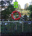
Emergency lifibelt by the Clyde
Opposite the West Boathouse at Glasgow Green.
Image: © Thomas Nugent
Taken: 8 Oct 2012
0.01 miles
2
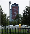
Gorbals high rise facelift
Viewed across Glasgow Green which was being prepared for the following day's Skyride cycling event, organised by Sky TV.
Image: © Thomas Nugent
Taken: 22 Aug 2009
0.02 miles
3
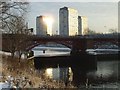
The Tidal Weir
The river is frozen above the weir.
Image: © Thomas Nugent
Taken: 9 Jan 2010
0.02 miles
4
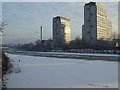
Frozen River Clyde
Just above the Tidal Weir, at Glasgow Green with The Gorbals high rise blocks in the background. Reminiscent of Moscow suburbs in winter.
Image: © Thomas Nugent
Taken: 9 Jan 2010
0.02 miles
5

Frozen River Clyde
Just above The Tidal Weir.
Image: © Thomas Nugent
Taken: 9 Jan 2010
0.02 miles
6
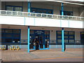
Adelphi Centre
Built on the site of Adelphi Secondary school. The Adelphi Centre is home to offices, conference rooms and educational facilities.
Image: © Lynn M Reid
Taken: 4 Apr 2008
0.02 miles
7
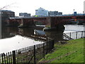
The Clyde Tidal Weir
Consists of three adjustable gates 80 feet long and 12 feet high. Its purpose is to retain a fixed water level upstream in order to stabilise the banking. Downstream is tidal. Completed in 1901 it is a Category B listed structure.
Image: © Chris Wimbush
Taken: 18 Feb 2007
0.03 miles
8
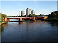
Pipe Bridge and Tidal Weir, River Clyde
The tidal weir seen from the Albert Bridge.
The weir keeps a fixed water level above this point. Downstream the river is tidal and alternates between fresh water and sea water. Seals are sometimes seen fishing here.
Image: © Richard Sutcliffe
Taken: 30 Aug 2010
0.03 miles
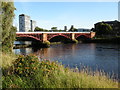
9

Pipe Bridge and Tidal Weir, River Clyde
The tidal weir from the Albert Bridge.
The obelisk in the background is the Nelson Monument in Glasgow Green, which dates from 1806.
Mute swans can be seen in the foreground.
Image: © Richard Sutcliffe
Taken: 30 Aug 2010
0.03 miles
10
Pipe Bridge and Tidal Weir, River Clyde
Seen from the north bank of the river.
Image: © Richard Sutcliffe
Taken: 30 Aug 2010
0.03 miles