IMAGES TAKEN NEAR TO
Oatlands Square, GLASGOW, G5 0GZ
Introduction
This page details the photographs taken nearby to Oatlands Square, G5 0GZ by members of the Geograph project.
The Geograph project started in 2005 with the aim of publishing, organising and preserving representative images for every square kilometre of Great Britain, Ireland and the Isle of Man.

There are currently over 7.5m images from over14,400 individuals and you can help contribute to the project by visiting https://www.geograph.org.uk
Image Map
Images are licensed for reuse under creativecommons.org/licenses/by-sa/2.0
Notes
- Clicking on the map will re-center to the selected point.
- The higher the marker number, the further away the image location is from the centre of the postcode.
Image Listing (59 Images Found)
Images are licensed for reuse under creativecommons.org/licenses/by-sa/2.0
Image
Details
Distance
2
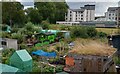
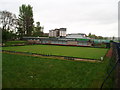
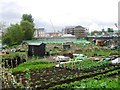
Oatlands Gate allotments
Hutchesontown Bowling Club beyond
Image: © Jim Smillie
Taken: 14 Jul 2022
0.06 miles
3
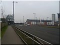
Approaching a roundabout on New Rutherglen Road
A section of the A730 which has been moved about 100 yards to the south - must be a recent development, as both the OS map and Google satellite images fail to show it.
Image: © Stephen Sweeney
Taken: 18 Feb 2009
0.09 miles
4
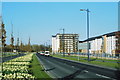
The Boulevard, Oatlands, Glasgow
The Boulevard was opened to traffic in November 2006, part of a new traffic by-pass for the Oatlands area, currently the subject of a major urban regeneration project led by Glasgow City Council (lead developer - Gladedale). Nearly 1,300 houses are being built and Richmond Park is being upgraded as part of the scheme.
Image: © RON SMITH
Taken: 22 Mar 2007
0.09 miles
6
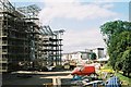
Haughview Terrace, Oatlands, Glasgow
Six-storey housing blocks under construction beside the River Clyde. These form part of the Oatlands Regeneration project, led by Glasgow City Council (lead developer - Gladedale). Nearly 1,300 houses are being built and Richmond Park is being upgraded as part of the scheme.
Image: © RON SMITH
Taken: 9 Aug 2007
0.10 miles
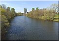
7
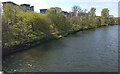
The River Clyde in Glasgow
Fairly new apartment blocks on the south bank at Haughview Terrace in Oatlands. Viewed from Polmadie Footbridge.
Image: © Thomas Nugent
Taken: 22 Apr 2022
0.10 miles
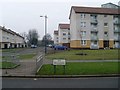
8
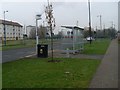
Bus stop, Caledonia Road
In a newly-developed area of Oatlands, south of Glasgow City Centre.
Image: © Stephen Sweeney
Taken: 18 Feb 2009
0.11 miles
9
The River Clyde in Glasgow
Glasgow Green is on the right in this view from Polmadie Footbridge.
Image: © Thomas Nugent
Taken: 22 Apr 2022
0.11 miles
10
The Boulevard
Name of this stretch of the new A730 in Oatlands.
Image: © Stephen Sweeney
Taken: 18 Feb 2009
0.13 miles