IMAGES TAKEN NEAR TO
Rosebery Terrace, GLASGOW, G5 0AS
Introduction
This page details the photographs taken nearby to Rosebery Terrace, G5 0AS by members of the Geograph project.
The Geograph project started in 2005 with the aim of publishing, organising and preserving representative images for every square kilometre of Great Britain, Ireland and the Isle of Man.

There are currently over 7.5m images from over14,400 individuals and you can help contribute to the project by visiting https://www.geograph.org.uk
Image Map
Images are licensed for reuse under creativecommons.org/licenses/by-sa/2.0
Notes
- Clicking on the map will re-center to the selected point.
- The higher the marker number, the further away the image location is from the centre of the postcode.
Image Listing (42 Images Found)
Images are licensed for reuse under creativecommons.org/licenses/by-sa/2.0
Image
Details
Distance
1
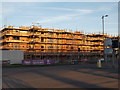
Oatlands housing development
New houses are being built in this area beside the M74.
Image: © Alec MacKinnon
Taken: 21 Jan 2017
0.02 miles
2
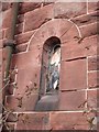
Broken Stained Glass.
Little window at St Margaret's church Polmadie Road.
Image: © Lynn M Reid
Taken: 24 Mar 2008
0.03 miles
3
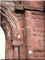
110 Polmadie Road
Stonework at St. Margaret's church
Image: © Lynn M Reid
Taken: 24 Mar 2008
0.04 miles
4
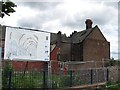
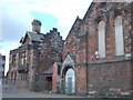
St Margaret's Oatlands
Former church, now derelict. It is hoped to convert the building to a community centre.
Image: © Richard Webb
Taken: 29 Jun 2011
0.05 miles
5
Doomed
This area of Polmadie, Glasgow, is in the path of the extension to the M74 motorway. It will soon be levelled for the roadworks to commence.
Image: © Roger May
Taken: 9 Aug 2005
0.05 miles
6
St. Margaret's Church, Polmadie Road.
It was in this church that my parents married. Me and my brother were also christened here. plans are proposed to convert it to a community centre for the regenerated Oatlands area.
Image: © Lynn M Reid
Taken: 24 Mar 2008
0.05 miles
7
Scoptland TranServ depot on New Rutherglen Road
Image: © Elliott Simpson
Taken: 28 Apr 2014
0.09 miles
8
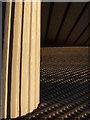
Pillar and bricks under the M74
One of the pillars that holds up the M74 carriageway is at left. The underside of the carriageway is at the top. Light from the setting Sun illuminates the brick banking.
Image: © Alec MacKinnon
Taken: 21 Jan 2017
0.10 miles
9
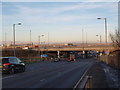
M74 crosses Polmadie Road
The picture looks north along Polmadie Road and shows the M74 motorway where it crosses the street.
Image: © Alec MacKinnon
Taken: 21 Jan 2017
0.11 miles
10
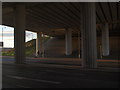
Under the M74
Late on a January afternoon the low Sun illuminates the underside of the carriageway of the M74 where it crosses Polmadie Road.
Image: © Alec MacKinnon
Taken: 21 Jan 2017
0.11 miles