IMAGES TAKEN NEAR TO
Rodney Street, GLASGOW, G4 9SF
Introduction
This page details the photographs taken nearby to Rodney Street, G4 9SF by members of the Geograph project.
The Geograph project started in 2005 with the aim of publishing, organising and preserving representative images for every square kilometre of Great Britain, Ireland and the Isle of Man.

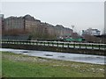
There are currently over 7.5m images from over14,400 individuals and you can help contribute to the project by visiting https://www.geograph.org.uk
Image Map
Images are licensed for reuse under creativecommons.org/licenses/by-sa/2.0
Notes
- Clicking on the map will re-center to the selected point.
- The higher the marker number, the further away the image location is from the centre of the postcode.
Image Listing (200 Images Found)
Images are licensed for reuse under creativecommons.org/licenses/by-sa/2.0
Image
Details
Distance
1
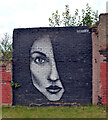
Street art by the Glasgow Branch of The Forth and Clyde Canal
This painting can be seen in context in Image
Image: © habiloid
Taken: 30 Jul 2021
0.02 miles
2
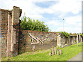
Old industrial wall by the canal
Old maps show the premises behind the wall to have been the Elmbank Foundry.
Image: © Stephen Craven
Taken: 25 Jun 2019
0.02 miles
3
The Glasgow Branch of The Forth and Clyde Canal
A close-up of the art on the left can be seen in Image
Image: © habiloid
Taken: 30 Jul 2021
0.02 miles
4
The Whisky Bond and the Forth & Clyde Canal
Taken on a Geograph walk, see Image] for more information.
Image: © Philip Halling
Taken: 25 Jun 2019
0.03 miles
5
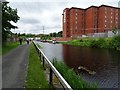
Forth and Clyde Canal
Spiers Wharf warehouses are visible in the background, as is the Cine World cinema complex on Renfrew Street.
Image: © Thomas Nugent
Taken: 13 Feb 2009
0.04 miles
6

The Whisky Bond, Dawson Road, Glasgow
Built beside the Forth & Clyde Canal in 1957 as a bonded warehouse for Highland Distilleries. Now renovated and in use as home to a community of designers, makers, creative businesses, artists and social innovators. There is also a cafe on the ground floor.
Image: © Richard Sutcliffe
Taken: 25 Jun 2019
0.05 miles
7
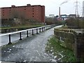
Forth and Clyde Canal
The aqueduct over Possil Road is in the foreground.
Image: © Thomas Nugent
Taken: 13 Feb 2009
0.05 miles
8
The Whisky Bond
Built in 1957 as a bonded warehouse for Highland Distilleries beside the Forth and Clyde Canal. Since 2012 it's been home to a community of designers, makers, creative businesses, artists and social innovators. See http://www.thewhiskybond.co.uk/about/.
Image: © Richard Sutcliffe
Taken: 9 Dec 2022
0.05 miles
9
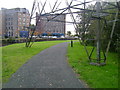
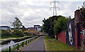
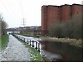
Slightly diverted towpath
The path alongside the Forth and Clyde Canal close to Spiers Wharf has been diverted from its original line to accommodate an electricity pylon.
Image: © Mark Nightingale
Taken: 30 Sep 2009
0.05 miles
10
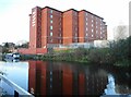
Forth and Clyde Canal
The Glasgow branch of the canal, looking towards Applecross Street from Spiers Wharf.
Image: © Thomas Nugent
Taken: 13 Feb 2009
0.05 miles