IMAGES TAKEN NEAR TO
Stewarton Road, GLASGOW, G46 7TB
Introduction
This page details the photographs taken nearby to Stewarton Road, G46 7TB by members of the Geograph project.
The Geograph project started in 2005 with the aim of publishing, organising and preserving representative images for every square kilometre of Great Britain, Ireland and the Isle of Man.

There are currently over 7.5m images from over14,400 individuals and you can help contribute to the project by visiting https://www.geograph.org.uk
Image Map
Images are licensed for reuse under creativecommons.org/licenses/by-sa/2.0
Notes
- Clicking on the map will re-center to the selected point.
- The higher the marker number, the further away the image location is from the centre of the postcode.
Image Listing (21 Images Found)
Images are licensed for reuse under creativecommons.org/licenses/by-sa/2.0
Image
Details
Distance
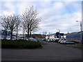
2
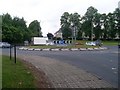
Spiersbridge Roundabout
Where Nitshill Road meets Spiersbridge Road.
Image: © Stephen Sweeney
Taken: 13 Jun 2009
0.08 miles
3
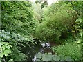
Rouken Glen
The Auldhouse Burn cuts through thick foliage in Rouken Glen.
Image: © Stephen Sweeney
Taken: 13 Jun 2009
0.14 miles
4
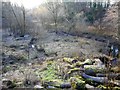
Former reservoir, Rouken Glen Park
This used to be a small reservoir - one of several on the Auldhouse Burn, which provided a head of water to power the nearby former Thornliebank Calico Printing Works, and Newfield and Thornliebank cotton mills.
Image: © Richard Sutcliffe
Taken: 4 Dec 2018
0.14 miles
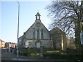
5
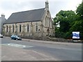
Thornliebank Parish Church
At the corner of Spiersbridge Road and Rouken Glen Road.
Image: © Stephen Sweeney
Taken: 13 Jun 2009
0.15 miles
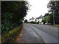
6
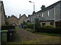
Housing at Rouken Glen Road
Bell tower is on Thornliebank Parish Church.
Image: © Alan Reid
Taken: 5 Nov 2018
0.15 miles
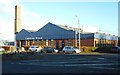
8
Thornliebank Industrial Estate
Thornlie Bank Industrial estate on a winter's day
Image: © Bob Shires
Taken: 6 Feb 2007
0.15 miles
9
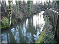
Auldhouse Burn
Here the Auldhouse Burn follows a man-made lade, which was part of a series of features which provided water to power the nearby former Thornliebank Calico Printing Works, and Newfield and Thornliebank cotton mills. The lade stands several metres above what used to be a reservoir just to the west [http://www.geograph.org.uk/photo/5994530].
Image: © Richard Sutcliffe
Taken: 4 Dec 2018
0.16 miles
10
Caledonia House, Thornliebank Industrial Estate
On Spiersbridge Avenue.
Image: © Richard Sutcliffe
Taken: 28 Nov 2017
0.16 miles