IMAGES TAKEN NEAR TO
Croftfoot Terrace, GLASGOW, G45 0NF
Introduction
This page details the photographs taken nearby to Croftfoot Terrace, G45 0NF by members of the Geograph project.
The Geograph project started in 2005 with the aim of publishing, organising and preserving representative images for every square kilometre of Great Britain, Ireland and the Isle of Man.

There are currently over 7.5m images from over14,400 individuals and you can help contribute to the project by visiting https://www.geograph.org.uk
Image Map
Images are licensed for reuse under creativecommons.org/licenses/by-sa/2.0
Notes
- Clicking on the map will re-center to the selected point.
- The higher the marker number, the further away the image location is from the centre of the postcode.
Image Listing (20 Images Found)
Images are licensed for reuse under creativecommons.org/licenses/by-sa/2.0
Image
Details
Distance
1
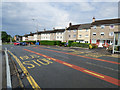
Castlemilk Drive
The bus stops near St Bartholomew's Primary School.
Image: © Thomas Nugent
Taken: 27 May 2017
0.06 miles
2

Croftfoot Drive and Croftfoot Road
Croftfoot Drive is in the foreground and Croftfoot Road, a main thoroughfare, is beyond. Tenements typical of the Castlemilk area are on the other side of Croftfoot Road.
Image: © Alec MacKinnon
Taken: 20 May 2018
0.07 miles
3

Castlemilk Drive
Between the junctions with Croftfoot Drive and Croftfoot Road.
Image: © Thomas Nugent
Taken: 27 May 2017
0.07 miles
4
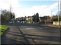
Crossroads in Croftfoot
Looking along Croftfoot Road at the intersection with Castlemilk Road.
Image: © G Laird
Taken: 27 Nov 2012
0.09 miles
5
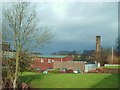
Braeside Primary School
This school is known to older generations as Braeside Primary. It is being utilized by St. Fillans Primary until their new facility is completed.
Image: © Lynn M Reid
Taken: 7 Mar 2008
0.09 miles
6
Croftfoot Road at Castlemilk Road
Old stone structures at the crossroads. Old maps show no buildings here.
Image: © Thomas Nugent
Taken: 27 May 2017
0.10 miles
7
Croftfoot Road at Castlemilk Road
Old stone structures at the crossroads. Old maps show no buildings here.
Image: © Thomas Nugent
Taken: 27 May 2017
0.10 miles
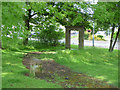
8
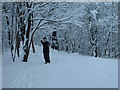
Is this Narnia?
Taken in the small wood behind St. Barts RC Church
Image: © Lynn M Reid
Taken: 12 Mar 2006
0.13 miles
9
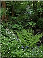
Plants and flowers in Castlemilk Park
Castlemilk Park is wooded and shady. Wild garlic and bluebells are both in bloom just now, all the way along the paths that follows the burn.
Image: © Alec MacKinnon
Taken: 20 May 2018
0.16 miles
