IMAGES TAKEN NEAR TO
Croftfoot Road, GLASGOW, G44 5LN
Introduction
This page details the photographs taken nearby to Croftfoot Road, G44 5LN by members of the Geograph project.
The Geograph project started in 2005 with the aim of publishing, organising and preserving representative images for every square kilometre of Great Britain, Ireland and the Isle of Man.

There are currently over 7.5m images from over14,400 individuals and you can help contribute to the project by visiting https://www.geograph.org.uk
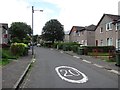
Image Map (Loading...)


Getting Data...Please wait
Leaflet Map data © OpenStreetMap
Images are licensed for reuse under creativecommons.org/licenses/by-sa/2.0
Notes
- Clicking on the map will re-center to the selected point.
- The higher the marker number, the further away the image location is from the centre of the postcode.
Image Listing (19 Images Found)
Images are licensed for reuse under creativecommons.org/licenses/by-sa/2.0
Image
Details
Distance
1
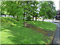
Croftfoot Road at Castlemilk Road
Old stone structures at the crossroads. Old maps show no buildings here.
Image: © Thomas Nugent
Taken: 27 May 2017
0.08 miles
2
Croftfoot Road at Castlemilk Road
Old stone structures at the crossroads. Old maps show no buildings here.
Image: © Thomas Nugent
Taken: 27 May 2017
0.08 miles
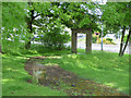
3
Path, Croftfoot
Between Croftside Avenue and Croftmont Avenue.
Image: © Richard Webb
Taken: 29 Jun 2011
0.08 miles
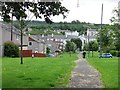
4
Crossroads in Croftfoot
Looking along Croftfoot Road at the intersection with Castlemilk Road.
Image: © G Laird
Taken: 27 Nov 2012
0.10 miles
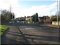
5

Castlemilk Drive
Between the junctions with Croftfoot Drive and Croftfoot Road.
Image: © Thomas Nugent
Taken: 27 May 2017
0.11 miles
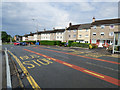
6
Croftside Avenue
Residential street, Croftfoot with a 20mph speed limit.
Image: © Richard Webb
Taken: 29 Jun 2011
0.13 miles
7
Castlemilk Drive
The bus stops near St Bartholomew's Primary School.
Image: © Thomas Nugent
Taken: 27 May 2017
0.13 miles
8

Croftfoot Drive and Croftfoot Road
Croftfoot Drive is in the foreground and Croftfoot Road, a main thoroughfare, is beyond. Tenements typical of the Castlemilk area are on the other side of Croftfoot Road.
Image: © Alec MacKinnon
Taken: 20 May 2018
0.14 miles
9
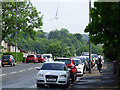
Castlemilk Road
Looking up the hill near Croftside Avenue. The wind turbine is at Cathkin Braes.
Image: © Thomas Nugent
Taken: 27 May 2017
0.15 miles
10

Castlemilk and Croftfoot
From Croftfoot Railway Station.
Image: © Stephen Sweeney
Taken: 1 Apr 2009
0.17 miles