IMAGES TAKEN NEAR TO
First Avenue, GLASGOW, G44 3UA
Introduction
This page details the photographs taken nearby to First Avenue, G44 3UA by members of the Geograph project.
The Geograph project started in 2005 with the aim of publishing, organising and preserving representative images for every square kilometre of Great Britain, Ireland and the Isle of Man.

There are currently over 7.5m images from over14,400 individuals and you can help contribute to the project by visiting https://www.geograph.org.uk
Image Map
Images are licensed for reuse under creativecommons.org/licenses/by-sa/2.0
Notes
- Clicking on the map will re-center to the selected point.
- The higher the marker number, the further away the image location is from the centre of the postcode.
Image Listing (36 Images Found)
Images are licensed for reuse under creativecommons.org/licenses/by-sa/2.0
Image
Details
Distance
1
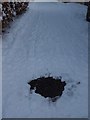
Manhole cover revealed in the snow
The manhole cover is one of several in the lane between First Avenue and Netherlee Primary School and its playing fields. There were a few inches of snow everywhere else but the manhole covers are apparently sufficiently warmed by domestic waste water that the snow doesn't settle on them.
Image: © Alec MacKinnon
Taken: 2 Dec 2010
0.01 miles
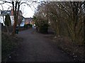
2
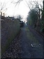
Lane behind First Avenue
The photo looks along the lane towards Clarkston Road. It is bounded by the backs of the houses on First Avenue, here to the left, and the sports pitch and Netherlee Primary School to the right, discretely concealed behind the big hedge.
Image: © Alec MacKinnon
Taken: 7 Mar 2010
0.01 miles
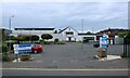
3
Netherlee Library
Run by East Renfrewshire Council.
Image: © Richard Sutcliffe
Taken: 13 Jul 2024
0.07 miles
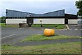
4
Netherlee Primary School
On Linnpark Avenue.
Image: © Richard Sutcliffe
Taken: 13 Jul 2024
0.08 miles
5
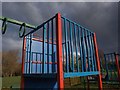
Playpark platform
The playpark beside Netherlee Pavilion includes the usual collection of swings, see-saws, chutes, hoops to hang off and wee platforms from which to launch oneself, like the one shown here.
Image: © Alec MacKinnon
Taken: 7 Apr 2014
0.08 miles
6
White Cart Walkway at First Avenue
Heading north along the White Cart Walkway you meet this fork. The Walkway proper continues towards Linn Park on the right fork while a lane runs to the right of the bush, taking you on to the end of First Avenue.
Image: © Alec MacKinnon
Taken: 7 Mar 2010
0.09 miles
7
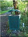
Bin on White Cart Walkway
This bin sits at the entrance, or I suppose exit depending on your direction, of the White Cart Walkway behind First Avenue.
Image: © Alec MacKinnon
Taken: 3 Oct 2010
0.10 miles
8
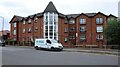
Netherlee Court
A block of flats on Clarkston Road.
Image: © Richard Sutcliffe
Taken: 13 Jul 2024
0.10 miles
9
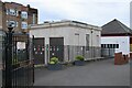
Electricity substation
Beside Netherlee Primary School.
Image: © Richard Sutcliffe
Taken: 13 Jul 2024
0.10 miles
10
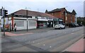
Shops, Clarkston Road
Clarkston Cycle Centre, Confectioner & tobacconist, Dough Balls (pizza delivery) Ash (hair care) and Nirvana (hair, beauty & makeup) on Clarkston Road.
Image: © Richard Sutcliffe
Taken: 13 Jul 2024
0.11 miles