IMAGES TAKEN NEAR TO
Brenfield Drive, GLASGOW, G44 3LT
Introduction
This page details the photographs taken nearby to Brenfield Drive, G44 3LT by members of the Geograph project.
The Geograph project started in 2005 with the aim of publishing, organising and preserving representative images for every square kilometre of Great Britain, Ireland and the Isle of Man.

There are currently over 7.5m images from over14,400 individuals and you can help contribute to the project by visiting https://www.geograph.org.uk
Image Map
Images are licensed for reuse under creativecommons.org/licenses/by-sa/2.0
Notes
- Clicking on the map will re-center to the selected point.
- The higher the marker number, the further away the image location is from the centre of the postcode.
Image Listing (80 Images Found)
Images are licensed for reuse under creativecommons.org/licenses/by-sa/2.0
Image
Details
Distance
1
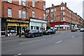
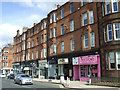
Shops and tenements
Discount Pet Supplies and Kenneth McPhee Optometrists on Clarkston Road. Hazel Avenue is to the left.
Image: © Richard Sutcliffe
Taken: 13 Jul 2024
0.08 miles
2
Shops on Clarkston Road
Hazel Avenue is to the right.
Image: © Thomas Nugent
Taken: 27 Apr 2013
0.08 miles
3
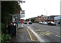
Bus stop and shelter on Clarkston Road (B767)
Image: © JThomas
Taken: 14 Sep 2021
0.08 miles
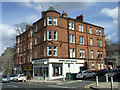
4
Clarkston Road
Red sandstone tenements with shops.
Image: © Richard Sutcliffe
Taken: 13 Jul 2024
0.08 miles
5
Shops on Clarkston Road
Looking towards Hazel Avenue.
Image: © Thomas Nugent
Taken: 27 Apr 2013
0.08 miles
6
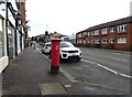
Clarkston Road (B767)
Showing position of Postbox No. G44 497.
See Image] for postbox.
Image: © JThomas
Taken: 14 Sep 2021
0.09 miles
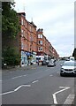
7
Clarkston Road
Looking towards the city centre from Cairndow Avenue.
Image: © Thomas Nugent
Taken: 27 Apr 2013
0.09 miles
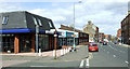
8
Little's Funeral Service
At the corner of Clarkston Road Cairndow Avenue.
Image: © Richard Sutcliffe
Taken: 13 Jul 2024
0.09 miles
9
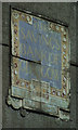
Ghost sign on Clarkston Road
The
Savings
Bank of
Glasgow
Safe Bind
Safe Find
On a tenement gable end, above the former Savings Bank of Glasgow building
Image: © Thomas Nugent
Taken: 27 Apr 2013
0.09 miles
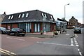
10
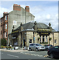
The Bank
The former Savings Bank of Glasgow building (also former Muirend Savings Bank) at the corner of Clarkston Road and Gartly Street.
The Category B Listed building became Muirend's first pub as recently as 2006.
See also Image & Image
Historic Scotland describes it as follows...
Bank, built 1925-27 to designs of A N Paterson and Stoddart. Renaissance; tall single storey with steep slate roof and occupying corner site. Polished ashlar, contrasting granite detail and plinth. Symmetrical tripartite front to Clarkston Road, iron-balconied centre 3-light window in Doric 'in antis' frame, parapet over with sculpted vase finials; arched recesses in outer bays with prominent key-stones (door to right, sculptured crest over); flank elevation to Gartly Street is a simplified version of the same composition. INTERIOR: large banking hall, coffered ceiling with elliptical centre cupola, original full-width counter and partition along north (rear) wall.
"The Savings bank of Glasgow" sign placed on gable of tenement adjoining (437 Clarkston Road) is presumably also the work of Paterson and Stoddart.
Image: © Thomas Nugent
Taken: 27 Apr 2013
0.09 miles