IMAGES TAKEN NEAR TO
Holeburn Road, GLASGOW, G43 2XW
Introduction
This page details the photographs taken nearby to Holeburn Road, G43 2XW by members of the Geograph project.
The Geograph project started in 2005 with the aim of publishing, organising and preserving representative images for every square kilometre of Great Britain, Ireland and the Isle of Man.

There are currently over 7.5m images from over14,400 individuals and you can help contribute to the project by visiting https://www.geograph.org.uk
Image Map
Images are licensed for reuse under creativecommons.org/licenses/by-sa/2.0
Notes
- Clicking on the map will re-center to the selected point.
- The higher the marker number, the further away the image location is from the centre of the postcode.
Image Listing (29 Images Found)
Images are licensed for reuse under creativecommons.org/licenses/by-sa/2.0
Image
Details
Distance
1
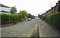
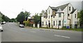
Holeburn Road
Looking southeast from Auldhouse Road. Holeburn Road ends as a culdesac at this end, and is separated from the main road by bollards.
The pillar box [http://www.geograph.org.uk/photo/5453700] is postbox number G43 900.
Image: © Richard Sutcliffe
Taken: 7 Jul 2017
0.04 miles
2
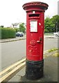
George V pillar box, Holeburn Road
The pillar box is postbox number G43 900.
Image: © Richard Sutcliffe
Taken: 7 Jul 2017
0.06 miles
3
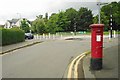
The end of Holeburn Road
Looking west towards Auldhouse Road. Holeburn Road ends as a culdesac here, and is separated from the main road by bollards.
The pillar box [http://www.geograph.org.uk/photo/5453700] is postbox number G43 900.
Image: © Richard Sutcliffe
Taken: 7 Jul 2017
0.06 miles
4
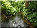
Auldhouse Burn
Seen from the footbridge in Greenbank Park.
Image: © Richard Sutcliffe
Taken: 7 Jul 2017
0.09 miles
5

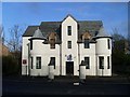
Drill hall, 230 Auldhouse Road
Purpose-built drill hall dating from during or shortly after the First World War. It is Category C listed [http://portal.historicenvironment.scot/designation/LB33914]. It is built in the Arts and Crafts style, making it very distinctive. It is currently home to D Platoon (RHF), Glasgow and Lanarkshire Battalion, Army Cadet Force.
Image: © Richard Sutcliffe
Taken: 7 Jul 2017
0.10 miles
6
Drill hall, 230 Auldhouse Road
Purpose-built drill hall dating from during or shortly after the First World War. It is Category C listed [http://portal.historicenvironment.scot/designation/LB33914]. It is built in the Arts and Crafts style, making it very distinctive. It is currently home to D Platoon (RHF), Glasgow and Lanarkshire Battalion, Army Cadet Force.
Image: © Richard Sutcliffe
Taken: 7 Jul 2017
0.11 miles
7
Glasgow and Lanarkshire Battalion ACF, Auldhouse Road
ACF stands for Army Cadet Forces.
Image: © Stephen Sweeney
Taken: 25 Feb 2009
0.11 miles
8
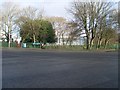
Auldhouse Park
Located at the junction of Auldhouse Road and Nether Auldhouse Road.
Image: © Stephen Sweeney
Taken: 25 Feb 2009
0.11 miles
9

Car park beside Homebase
At Auldhouse Retail Park on Cogan Street.
Image: © Richard Sutcliffe
Taken: 8 Sep 2023
0.16 miles
10
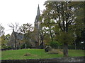
Eastwood Parish Church
Church of Scotland on Mansewood Road near the fork in the road with Thornliebank Road.
Image: © G Laird
Taken: 30 Oct 2013
0.16 miles