IMAGES TAKEN NEAR TO
Battlefield Road, GLASGOW, G42 9QH
Introduction
This page details the photographs taken nearby to Battlefield Road, G42 9QH by members of the Geograph project.
The Geograph project started in 2005 with the aim of publishing, organising and preserving representative images for every square kilometre of Great Britain, Ireland and the Isle of Man.

There are currently over 7.5m images from over14,400 individuals and you can help contribute to the project by visiting https://www.geograph.org.uk
Image Map
Images are licensed for reuse under creativecommons.org/licenses/by-sa/2.0
Notes
- Clicking on the map will re-center to the selected point.
- The higher the marker number, the further away the image location is from the centre of the postcode.
Image Listing (143 Images Found)
Images are licensed for reuse under creativecommons.org/licenses/by-sa/2.0
Image
Details
Distance
1
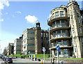
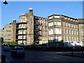
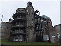
The Victoria Infirmary
The Battlefield Road side of the older part of the hospital complex. The Battle of Langside monument is visible on the extreme left.
Image: © Thomas Nugent
Taken: 27 Apr 2013
0.02 miles
2
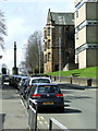
Battlefield Road
The Battle of Langside monument is visible on the extreme left.
Image: © Thomas Nugent
Taken: 27 Apr 2013
0.02 miles
3
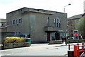
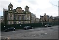
Tesco Express on Millbrae Road
A Category C Listed building on Millbrae Road. Built in 1937-39, designed by Sam Bunton (who also designed the Red Road Flats) in the Modern Movement style as a control station for the city lighting department.
The building served as a pub until 2009 and was converted to Tesco Express in 2010.
Here is a http://data.historic-scotland.gov.uk/pls/htmldb/f?p=2200:15:0::::BUILDING:33798 to the listing text.
Image: © Thomas Nugent
Taken: 27 Apr 2013
0.05 miles
4
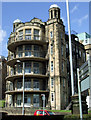
The Victoria Infirmary
Semi-circular balconies on the Battlefield Road side of the building. Viewed from Sinclair Drive.
Image: © Thomas Nugent
Taken: 27 Apr 2013
0.06 miles
5
Victoria Infirmary, Glasgow
This present building is soon being moved to a new site across the road from here.
Image: © Stephen Sweeney
Taken: 28 Jan 2009
0.06 miles
6
Former Victoria Infirmary
The building on the left was the administration block dating from 1889-90. It is Category B listed.
Image: © Richard Sutcliffe
Taken: 5 Mar 2017
0.06 miles
7
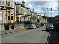
Overdale Street
Looking down the hill from Millbrae Road.
Image: © Thomas Nugent
Taken: 27 Apr 2013
0.06 miles
8
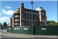
Former Victoria Infirmary
Much of the hospital has been demolished, but the Nightingale Wards seen here will be incorporated into a new housing development on the site.
Image: © Thomas Nugent
Taken: 26 Sep 2020
0.06 miles
9
The Victoria Infirmary, Glasgow
See http://www.archives.gla.ac.uk/gghb/collects/hb23.html for history of the hospital. I think the railed balconies would be for the open-air treatment of TB patients.
Image: © Barbara Carr
Taken: 19 Mar 2013
0.06 miles
10
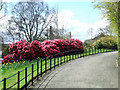
Queens Park
A blaze of colour from the Rhododendrons at the Langside Road end of the park.
Image: © Thomas Nugent
Taken: 27 Apr 2013
0.06 miles