IMAGES TAKEN NEAR TO
Cathkinview Place, GLASGOW, G42 9EW
Introduction
This page details the photographs taken nearby to Cathkinview Place, G42 9EW by members of the Geograph project.
The Geograph project started in 2005 with the aim of publishing, organising and preserving representative images for every square kilometre of Great Britain, Ireland and the Isle of Man.

There are currently over 7.5m images from over14,400 individuals and you can help contribute to the project by visiting https://www.geograph.org.uk
Image Map
Images are licensed for reuse under creativecommons.org/licenses/by-sa/2.0
Notes
- Clicking on the map will re-center to the selected point.
- The higher the marker number, the further away the image location is from the centre of the postcode.
Image Listing (76 Images Found)
Images are licensed for reuse under creativecommons.org/licenses/by-sa/2.0
Image
Details
Distance
1
Langside Court and Battlefield Court
Viewed from Queens Park.
Image: © Thomas Nugent
Taken: 27 Apr 2013
0.01 miles
2
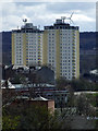
Langside Court and Battlefield Court
Viewed from Queens Park.
Image: © Thomas Nugent
Taken: 27 Apr 2013
0.01 miles
4
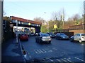
Railway bridge at Mount Florida Station
Over Battlefield Road.
Image: © Stephen Sweeney
Taken: 28 Jan 2009
0.03 miles
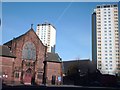
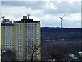
6
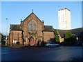
Battlefield church and highrise
The church is situated between Cathcart Road and Battlefield Road.
Image: © Stephen Sweeney
Taken: 28 Jan 2009
0.07 miles
7
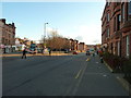
No Waiting on Cathcart Road
The nearby League Cup Final at Hampden Park means all streets in the area have restricted parking and an increased police presence on the sunday afternoon to manage the crowd of nearly 50,000 football fans.
Image: © Andy Farrington
Taken: 18 Mar 2012
0.08 miles
8
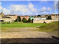
Football practice
The practice pitches outside Hampden Park Stadium, at Mount Florida, Glasgow.
Image: © Roger May
Taken: 8 Aug 2005
0.08 miles
9
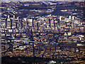
Glasgow from the air
The Victoria Infirmary and Queens Park can be seen in the foreground, with Victoria Road heading north to the city centre where the two largest glass roofs in the world can be seen at Glasgow Central railway station and St Enoch Shopping Centre. The elevated M74 northern extension can be seen in the left foreground. In the left distance, the developments around the former distillery at Port Dundas are visible as are the developments at the site of the Sighthill towerblocks in the right distance. The recently electrified Glasgow to Edinburgh railway line can be seen near the top centre.
Viewed from a Prague bound flight just north of Darvel, which is around 15 miles from the city centre.
Image: © Thomas Nugent
Taken: 3 Dec 2018
0.08 miles
10
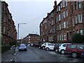
Bolton Drive
Looking from Mount Florida railway station in the direction of Hampden Park.
Image: © Thomas Nugent
Taken: 30 Dec 2009
0.09 miles