IMAGES TAKEN NEAR TO
Prince Edward Street, GLASGOW, G42 8LU
Introduction
This page details the photographs taken nearby to Prince Edward Street, G42 8LU by members of the Geograph project.
The Geograph project started in 2005 with the aim of publishing, organising and preserving representative images for every square kilometre of Great Britain, Ireland and the Isle of Man.

There are currently over 7.5m images from over14,400 individuals and you can help contribute to the project by visiting https://www.geograph.org.uk
Image Map
Images are licensed for reuse under creativecommons.org/licenses/by-sa/2.0
Notes
- Clicking on the map will re-center to the selected point.
- The higher the marker number, the further away the image location is from the centre of the postcode.
Image Listing (241 Images Found)
Images are licensed for reuse under creativecommons.org/licenses/by-sa/2.0
Image
Details
Distance
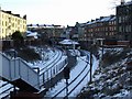
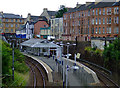
1
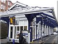
Queen's Park railway station
A traditional island platform station on the Catchart Circle, between Pollokshields East and Crosshill stations. Queen's Park is also served by the Neilston and Newton services.
Image: © Thomas Nugent
Taken: 30 Dec 2009
0.03 miles
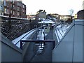
2
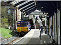
Queens Park railway station
On the Cathcart Circle line on the south side of the city. Class 314 train number 314 208 pulling out of Platform 2, bound for Neilston.
Image: © Thomas Nugent
Taken: 27 Apr 2013
0.03 miles
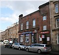
3
Victoria Road
Church and bank at the corner of Prince Edward Street.
Image: © Thomas Nugent
Taken: 6 Jan 2010
0.03 miles
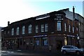
4
Bank of Scotland and the Tron Church
The entrance to the Tron Church, Queen's Park on Prince Edward Street, beside the Bank of Scotland. The church occupies part of the first floor, and also faces onto Victoria Road.
Image: © Richard Sutcliffe
Taken: 5 Mar 2017
0.03 miles
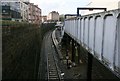
5
Queens Park railway station
Hemmed in by tenements on all sides, viewed from the road bridge at Niddrie Road.
Image: © Thomas Nugent
Taken: 6 Jan 2010
0.03 miles
6
Queens Park railway station
Viewed from the Victoria Road steps.
Image: © Thomas Nugent
Taken: 6 Jan 2010
0.03 miles
7
Queens Park Station
Viewed from Victoria Road.
Image: © Richard Sutcliffe
Taken: 5 Mar 2017
0.04 miles
8

Queens Park railway station, Glasgow
Opened in 1886 by the Cathcart District Railway, now the Cathcart Circle line.
View south east towards Crosshill and Cathcart.
Image: © Nigel Thompson
Taken: 26 Mar 2011
0.04 miles
9
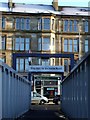
Way out to Victoria Road
One of the exits from Queens Park railway station.
Image: © Thomas Nugent
Taken: 6 Jan 2010
0.04 miles
10
Queens Park railway station
As seen from the Niddrie Street entrance. Victoria Road is in the distance.
Image: © Thomas Nugent
Taken: 31 Jul 2011
0.04 miles