IMAGES TAKEN NEAR TO
Queens Drive, GLASGOW, G42 8BS
Introduction
This page details the photographs taken nearby to Queens Drive, G42 8BS by members of the Geograph project.
The Geograph project started in 2005 with the aim of publishing, organising and preserving representative images for every square kilometre of Great Britain, Ireland and the Isle of Man.

There are currently over 7.5m images from over14,400 individuals and you can help contribute to the project by visiting https://www.geograph.org.uk
Image Map
Images are licensed for reuse under creativecommons.org/licenses/by-sa/2.0
Notes
- Clicking on the map will re-center to the selected point.
- The higher the marker number, the further away the image location is from the centre of the postcode.
Image Listing (43 Images Found)
Images are licensed for reuse under creativecommons.org/licenses/by-sa/2.0
Image
Details
Distance
1
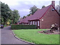
Crosshill Avenue
On the original site of Crosshill House with links back to Medieval times this sheltered housing project in Crosshill Avenue is a simple design of a Town-scape (red brick, small-paned casements, red tile roofs etc.) They became category ‘B’ listed buildings in 1949 forty years after construction. It received a Festival of Britain Award of Merit in 1951.
Image: © Alan Murray Walsh
Taken: 20 Sep 2008
0.04 miles
2
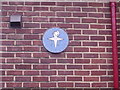
Blue plaque
Festival of Britain Award of Merit in 1951.
Image: © Alan Murray Walsh
Taken: 20 Sep 2008
0.04 miles
3
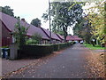
Crosshill Av
On the original site of Crosshill House with links back to Medieval times this sheltered housing project in Crosshill Av. is a simple design of a Townscape (red brick, small-paned casements, red tile roofs etc.) They became category ‘B’ listed buildings in 1949 forty years after construction. It received a Festival of Britain Award of Merit in 1951.
Image: © Alan Murray Walsh
Taken: 20 Sep 2008
0.06 miles
4
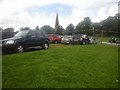
Queen's Park used as Olympic 2012 carpark
The scene represents cars parking just prior to the women's football game between the USA and Colombia.
Image: © C Michael Hogan
Taken: 28 Jul 2012
0.08 miles
5

Mural commemorating first Hampden Park
The mural went up in 2019, and is painted on the back of Hampden Bowling Club's clubhouse. Two years earlier someone at the club, which had long maintained it was sited on the land once occupied by the world's first international football stadium, had found a railway company map somewhere that showed the plans for the railway line seen in the picture to bisect the pitch. Due to the fact that the ground was built after the first OS map and demolished to make way for the new railway before the second OS map got surveyed there had until then been no conclusive proof.
Considering that for years nobody was entirely sure exactly where the ground had been, other facts and figures about the place should probably be treated with a bit of caution. A standout one is that the pitch dimensions inside this first national stadium were apparently a huge 200 yards by 100 yards. Scotland hosted six matches during the ground's 11 year existence and won them all, scoring at least five goals in each game - England and Wales lost three apiece. Queen's Park F.C. held the lease and played their home games here, as was the case at the two subsequent Hampden Parks until as recently as 2021.
The
quite brilliant ludicrousness of a team of increasingly dwindling stature, with average attendances in the low to mid hundreds, playing their matches in a 50,000 capacity national stadium had to come to an end sometime I suppose, and the SFA now own the latest Hampden Park. Queen's Park are currently ground-sharing whilst their former training pitch, Lesser Hampden, is brought up to standard.
It is odd that the 5-1 win is the one the mural celebrates, considering that they also beat England 7-2 on this same ground. I have not checked, but it could be that one or both of the two iconic players - Charles Campbell and Andrew Watson - that flank the scoreline did not feature in the bigger victory.
Scotland dominated England in the early years of football. Whilst the head-to-head record is currently 48-41 in England's favour, Scotland were 29-19 ahead at the outbreak of the Second World War.
A match report of an early game here alludes to the fact that in the old rules every time a goal was scored the teams had to change ends. This rule was dropped in 1875. The stadium existed from 1873 to 1884.
Image: © Ian Dodds
Taken: 28 Mar 2023
0.09 miles
6
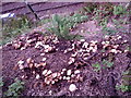
Fungus patch
On the banking of the train line between Mount Florida & Govanhill stations.
Image: © Alan Murray Walsh
Taken: 20 Sep 2008
0.10 miles
7
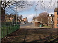
Cathcart Road from Cathkin Park
The picture looks out from the entrance to Cathkin Park, north along Cathcart Road.
Image: © Alec MacKinnon
Taken: 8 Mar 2015
0.11 miles
8

Crosshill House hotel
Crosshill House hotel in Queen Mary Avenue, Glasgow.
Image: © Peter Mackenzie
Taken: 12 Sep 2018
0.12 miles
9
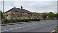
Houses on Cathcart Road
Local authority housing on Cathcart Road in Glasgow.
Image: © Peter Mackenzie
Taken: 3 May 2019
0.14 miles
10
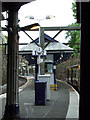
Crosshill railway station
Like many on the Cathcart Circle line, Crosshill station is in a cutting with an island platform.
Image: © Thomas Nugent
Taken: 1 Jun 2013
0.16 miles