IMAGES TAKEN NEAR TO
Albert Drive, GLASGOW, G41 4JB
Introduction
This page details the photographs taken nearby to Albert Drive, G41 4JB by members of the Geograph project.
The Geograph project started in 2005 with the aim of publishing, organising and preserving representative images for every square kilometre of Great Britain, Ireland and the Isle of Man.

There are currently over 7.5m images from over14,400 individuals and you can help contribute to the project by visiting https://www.geograph.org.uk
Image Map
Images are licensed for reuse under creativecommons.org/licenses/by-sa/2.0
Notes
- Clicking on the map will re-center to the selected point.
- The higher the marker number, the further away the image location is from the centre of the postcode.
Image Listing (30 Images Found)
Images are licensed for reuse under creativecommons.org/licenses/by-sa/2.0
Image
Details
Distance
1
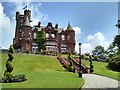
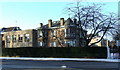
Sherbrooke Castle Hotel
Large red sandstone Scots Baronial villa, now a hotel, dating from 1896. It is Category B listed [http://portal.historicenvironment.scot/designation/LB33468].
Image: © Richard Sutcliffe
Taken: 11 Jul 2019
0.14 miles
2
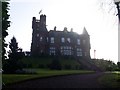
Sherbrooke Castle Hotel
Former castle and now hotel in the Pollokshields area of Glasgow.
Image: © Stephen Sweeney
Taken: 25 Feb 2009
0.14 miles
4
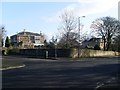
Junction of Springkell Avenue and Albert Drive
Image: © Richard Sutcliffe
Taken: 9 Feb 2018
0.16 miles
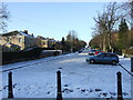
5
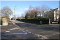
Nithsdale Road at Albert Drive
Road junction in the plush western side of Pollokshields.
Image: © Stephen Sweeney
Taken: 25 Feb 2009
0.17 miles
6
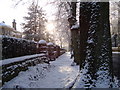
Dalziel Drive
Viewed from St Andrews Drive.
Image: © Thomas Nugent
Taken: 6 Jan 2010
0.19 miles
7
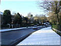
Nithsdale Road
View west from St Andrews Drive.
Image: © Thomas Nugent
Taken: 6 Jan 2010
0.20 miles
8
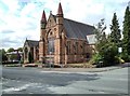
Sherbrooke Mosspark Parish Church
The Category B listed church [http://portal.historicenvironment.scot/designation/LB33453] was built as Sherbrooke UF Church, and opened in 1900. It was severely damaged by fire in 1994, and has since been extensively restored, including some beautiful modern stained-glass windows [https://www.geograph.org.uk/photo/1672915].
Image: © Richard Sutcliffe
Taken: 11 Jul 2019
0.20 miles
9
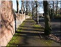
Wall and pavement, Springkell Avenue
The wall is included in the designation of the Category B listed house to which it belongs [http://portal.historicenvironment.scot/designation/LB33471].
Image: © Richard Sutcliffe
Taken: 9 Feb 2018
0.21 miles
10
Craigholme School
On St Andrews Drive at Dalziel Drive, overlooking Maxwell Park.
Image: © Thomas Nugent
Taken: 6 Jan 2010
0.22 miles