IMAGES TAKEN NEAR TO
Morton Gardens, GLASGOW, G41 4AF
Introduction
This page details the photographs taken nearby to Morton Gardens, G41 4AF by members of the Geograph project.
The Geograph project started in 2005 with the aim of publishing, organising and preserving representative images for every square kilometre of Great Britain, Ireland and the Isle of Man.

There are currently over 7.5m images from over14,400 individuals and you can help contribute to the project by visiting https://www.geograph.org.uk
Image Map
Images are licensed for reuse under creativecommons.org/licenses/by-sa/2.0
Notes
- Clicking on the map will re-center to the selected point.
- The higher the marker number, the further away the image location is from the centre of the postcode.
Image Listing (27 Images Found)
Images are licensed for reuse under creativecommons.org/licenses/by-sa/2.0
Image
Details
Distance
1
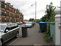
Fotheringay Road
Looking roughly WSW along Fotheringay Road. Taken from the entrance to Maxwell Park railway station.
Image: © Andrew Reid
Taken: 31 Aug 2011
0.08 miles
3
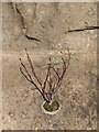
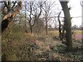
Shawmoss Road railway bridge shrub
The shrub is growing on the wall at the end of the embankment where the railway crosses Shawmoss Road (at the left-hand side of Image). At just after 9.00 AM on a February morning it is illuminated by direct sunlight.
Image: © Alec MacKinnon
Taken: 21 Feb 2015
0.08 miles
5
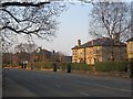
Haggs Road
Houses have a view of Pollok Park as well as a big road.
Image: © Richard Webb
Taken: 9 Apr 2013
0.12 miles
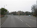
6
Bend in Haggs Road
Approaching the junction with Dumbreck Road and Titwood Road.
Image: © Stephen Sweeney
Taken: 25 Feb 2009
0.13 miles
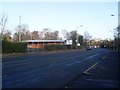
7

Craigholme School Sports Complex
On the outskirts of Pollok Country Park, next to Haggs Road.
Image: © Stephen Sweeney
Taken: 25 Feb 2009
0.14 miles
8
The B769 to Pollokshaws and the Burrell Collection
The Burrell Collection is housed within Pollok Park.
Image: © Barbara Carr
Taken: 22 Apr 2013
0.15 miles
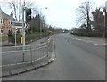
9
Road Junction on the B768 beside Pollok Park
The B768 continues straight through eventually leading to Rutherglen, while the B769 branching off to the right leads to Thornliebank.
Image: © G Laird
Taken: 21 Mar 2009
0.15 miles
10
Roadside strip, Pollok Park
Beyond the woodland along Haggs Road, there are sports facilities. The woodland was established as a roadside strip, the tennis courts etc were built on parkland.
Image: © Richard Webb
Taken: 9 Apr 2013
0.16 miles