IMAGES TAKEN NEAR TO
Shields Road, GLASGOW, G41 2RW
Introduction
This page details the photographs taken nearby to Shields Road, G41 2RW by members of the Geograph project.
The Geograph project started in 2005 with the aim of publishing, organising and preserving representative images for every square kilometre of Great Britain, Ireland and the Isle of Man.

There are currently over 7.5m images from over14,400 individuals and you can help contribute to the project by visiting https://www.geograph.org.uk
Image Map
Images are licensed for reuse under creativecommons.org/licenses/by-sa/2.0
Notes
- Clicking on the map will re-center to the selected point.
- The higher the marker number, the further away the image location is from the centre of the postcode.
Image Listing (108 Images Found)
Images are licensed for reuse under creativecommons.org/licenses/by-sa/2.0
Image
Details
Distance
1
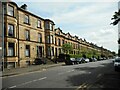
Shields Road
A long terrace between Albert Drive and Leslie Street, dating from 1874-76. The entire terrace is Category B listed http://portal.historicenvironment.scot/designation/LB33479.
Image: © Richard Sutcliffe
Taken: 14 May 2022
0.04 miles
2
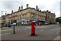
Shops on Albert Drive, Pollokshields
Showing position of Postbox No. G41 187.
See Image] for postbox.
Image: © JThomas
Taken: 14 Sep 2021
0.04 miles
3
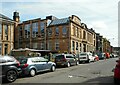
Pollokshields Primary School
Seen from Herriet Street. The part of the school on the left dates from 1882. The part seen here is a later extension from 1901. The whole school is Category B listed http://portal.historicenvironment.scot/designation/LB33370.
Image: © Richard Sutcliffe
Taken: 14 May 2022
0.05 miles
4
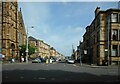
Albert Drive
Looking across Shields Road. Pollokshields Church is on the left.
Image: © Richard Sutcliffe
Taken: 14 May 2022
0.05 miles
5

Albert Drive & Pollokshields Church of Scotland, Glasgow
Image: © Leslie Barrie
Taken: 27 Apr 2013
0.05 miles
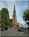
6
Pollokshields Church
At the corner of Shields Road and Albert Drive.
Image: © JThomas
Taken: 14 Sep 2021
0.06 miles
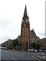
7
Pollokshields Church
The Category B listed http://portal.historicenvironment.scot/designation/LB33477 church was built in 1878. The spire is a prominent landmark.
Image: © Richard Sutcliffe
Taken: 14 May 2022
0.06 miles
8
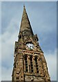
Pollokshields Church
Looking up to the spire and top of the tower of the Category B listed http://portal.historicenvironment.scot/designation/LB33477 church, which was built in 1878.
Image: © Richard Sutcliffe
Taken: 14 May 2022
0.06 miles
9
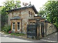
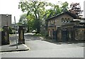
Lodge to The Knowe
Originally a coachhouse, the lodge was built 1852-56 in a similar style to The Knowe, which is 'Greek' Thomson's earliest surviving villa. The distinctive gatepiers still have their original timber gates. The house and lodge, with the boundary walls, gate piers and gates are Category A listed http://portal.historicenvironment.scot/designation/LB33371.
Image: © Richard Sutcliffe
Taken: 14 May 2022
0.06 miles
10
Gateway and Lodge to The Knowe
Originally a coachhouse, the lodge was built 1852-56 in a similar style to The Knowe, which is 'Greek' Thomson's earliest surviving villa. The distinctive gatepiers still have their original timber gates. The house and lodge, with the boundary walls, gate piers and gates are Category A listed http://portal.historicenvironment.scot/designation/LB33371.
Image: © Richard Sutcliffe
Taken: 14 May 2022
0.06 miles