IMAGES TAKEN NEAR TO
Nithsdale Drive, GLASGOW, G41 2PT
Introduction
This page details the photographs taken nearby to Nithsdale Drive, G41 2PT by members of the Geograph project.
The Geograph project started in 2005 with the aim of publishing, organising and preserving representative images for every square kilometre of Great Britain, Ireland and the Isle of Man.

There are currently over 7.5m images from over14,400 individuals and you can help contribute to the project by visiting https://www.geograph.org.uk
Image Map
Images are licensed for reuse under creativecommons.org/licenses/by-sa/2.0
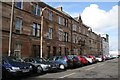
Notes
- Clicking on the map will re-center to the selected point.
- The higher the marker number, the further away the image location is from the centre of the postcode.
Image Listing (226 Images Found)
Images are licensed for reuse under creativecommons.org/licenses/by-sa/2.0
Image
Details
Distance
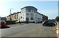
2

Car dealership on Nithsdale Drive (B763), Glasgow
Image: © JThomas
Taken: 14 Sep 2021
0.02 miles
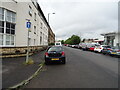
3

Entrance to former Arnold Clark premises
The former service centre for Arnold Clark closed sometime between 2020 and 2022. The premises were used in 2023 for consultation events for proposed residential developments on the site.
Image: © Richard Sutcliffe
Taken: 8 Sep 2023
0.02 miles
4

Former Arnold Clark garage
The service centre for the car showroom further down Nithsdale Drive. Both closed sometime between 2020 and 2022. There is still a ghost sign 'Vauxhall' on the side of the building.
Image: © Richard Sutcliffe
Taken: 8 Sep 2023
0.02 miles
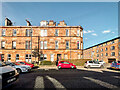
5
Flats on the corner
A modern block of flats on the corner of March Street and Nithsdale Drive.
Image: © Richard Sutcliffe
Taken: 8 Sep 2023
0.03 miles
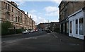
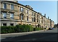
6
March Street
The more ornate sandstone building near the centre of the street is the former Strathbungo Police Station. Strathbungo was a separate village, but became part of Glasgow in 1891 and the police station closed in 1893.
Image: © Richard Sutcliffe
Taken: 5 Mar 2017
0.03 miles
7
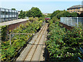
Railway tracks
Part of the Cathcart Circle between Queens Park and Pollokshields East.
Image: © Richard Sutcliffe
Taken: 8 Sep 2023
0.04 miles
8
Nithsdale Street
Category B and C listed buildings https://portal.historicenvironment.scot/designation/LB32391 https://portal.historicenvironment.scot/designation/LB32396 https://portal.historicenvironment.scot/designation/LB32395 on Nithsdale Street.
Image: © Richard Sutcliffe
Taken: 8 Sep 2023
0.04 miles