IMAGES TAKEN NEAR TO
Albert Drive, GLASGOW, G41 2NB
Introduction
This page details the photographs taken nearby to Albert Drive, G41 2NB by members of the Geograph project.
The Geograph project started in 2005 with the aim of publishing, organising and preserving representative images for every square kilometre of Great Britain, Ireland and the Isle of Man.

There are currently over 7.5m images from over14,400 individuals and you can help contribute to the project by visiting https://www.geograph.org.uk
Image Map
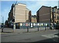
Images are licensed for reuse under creativecommons.org/licenses/by-sa/2.0
Notes
- Clicking on the map will re-center to the selected point.
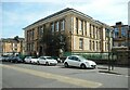
- The higher the marker number, the further away the image location is from the centre of the postcode.
Image Listing (170 Images Found)
Images are licensed for reuse under creativecommons.org/licenses/by-sa/2.0
Image
Details
Distance
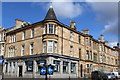
1
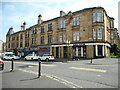
Tower Buildings, Albert Drive
Tenements with shops on Albert Drive dating from about 1900. They are Category B listed http://portal.historicenvironment.scot/designation/LB33369.
Image: © Richard Sutcliffe
Taken: 14 May 2022
0.01 miles
2
Pollokshields Medical Centre
In the tenement on the corner of Keir Street and Albert Drive.
Image: © Richard Sutcliffe
Taken: 14 May 2022
0.02 miles
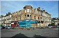
3
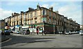
Tenements and shops
At Albert Cross (the junction of Albert Drive and Kenmure Street).
Image: © Richard Sutcliffe
Taken: 14 May 2022
0.03 miles
4
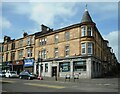
Bank of Scotland
On the corner of Albert Drive and Keir Street.
Image: © Richard Sutcliffe
Taken: 14 May 2022
0.03 miles
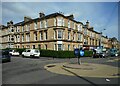
5
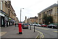
Albert Drive, Pollokshields
Showing position of Postbox No. G41 187.
See Image] for postbox.
Image: © JThomas
Taken: 14 Sep 2021
0.04 miles
6
Bank of Scotland, corner of Albert Drive & Keir Street, Glasgow
Image: © Leslie Barrie
Taken: 27 Apr 2013
0.04 miles
7
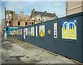
Colourful panels
On the hoardings beside a gap site Image on the corner of Kenmure Street and Albert Drive. The site previously housed a tenement property with ground floor shop. There was a fire there in November 2019 and the building could not be saved following an assessment by the Council’s Building Standards and Public Safety division and was ultimately demolished.
In the distance, on the other side of Albert Drive is another fire-damaged property Image
Image: © Richard Sutcliffe
Taken: 14 May 2022
0.04 miles
8
Fire-damaged properties
The corner tenement building at Albert Cross (the junction of Kenmure Street Albert Drive). It was gutted by fire in April 2020. The late 19th century building is Category B listed http://portal.historicenvironment.scot/designation/LB33377.
Image: © Richard Sutcliffe
Taken: 14 May 2022
0.04 miles
9
Corner gap site
The site previously housed a tenement property with ground floor shop. There was a fire there in November 2019 and the building partly collapsed and could not be saved following an assessment by the Council’s Building Standards and Public Safety division and was ultimately demolished. Together with neighbouring propertie, it had been Category B listed http://portal.historicenvironment.scot/designation/LB33368.
Image: © Richard Sutcliffe
Taken: 14 May 2022
0.04 miles
10
Pollokshields Primary School
The school dates from 1882 and was originally the Albert Road Public School. It was later extended in 1901. The whole school is Category B listed http://portal.historicenvironment.scot/designation/LB33370.
Image: © Richard Sutcliffe
Taken: 14 May 2022
0.04 miles