IMAGES TAKEN NEAR TO
Leven Street, GLASGOW, G41 2JB
Introduction
This page details the photographs taken nearby to Leven Street, G41 2JB by members of the Geograph project.
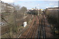
The Geograph project started in 2005 with the aim of publishing, organising and preserving representative images for every square kilometre of Great Britain, Ireland and the Isle of Man.

There are currently over 7.5m images from over14,400 individuals and you can help contribute to the project by visiting https://www.geograph.org.uk
Image Map
Images are licensed for reuse under creativecommons.org/licenses/by-sa/2.0
Notes
- Clicking on the map will re-center to the selected point.
- The higher the marker number, the further away the image location is from the centre of the postcode.
Image Listing (211 Images Found)
Images are licensed for reuse under creativecommons.org/licenses/by-sa/2.0
Image
Details
Distance
1
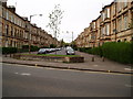
Leven Street Pollokshields
Pictured at its junction with Darnley Street on the South side of Glasgow.
Image: © Gordon Dowie
Taken: 4 May 2010
0.02 miles
2
Zia-ul-Quran Centre
At the corner of Leven Street and Kenmure Street.
According to their Facebook page: Zia-ul-Quran was established in December 1995 to meet the educational needs of the Muslim community in Pollokshields (Glasgow) and its surrounding localities. The core work involves providing religious instruction in the traditional Islamic Sciences for children and adults in a way that is relevant to Muslims living in the West.
Image: © Richard Sutcliffe
Taken: 14 May 2022
0.04 miles
3
Kenmure Street
Looking across Nithsdale Road into Kenmure Street.
Image: © Thomas Nugent
Taken: 6 Jan 2010
0.05 miles
4
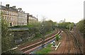
Railway between Pollokshaws West and Pollokshaws East stations
Seen from the bridge on Nithsdale Road.
Image: © Richard Sutcliffe
Taken: 4 May 2006
0.07 miles
5
Railway between Pollokshaws West and Pollokshaws East stations
Seen from the bridge on Nithsdale Road.
Image: © Richard Sutcliffe
Taken: 5 Mar 2017
0.07 miles
6
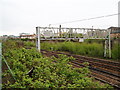
Overhead Gantry
On the rail line heading South from Central Station the line leads to Barrhead, East Kilbride and Kilmarnock among others.
Image: © Gordon Dowie
Taken: 4 May 2010
0.08 miles
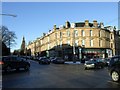
7
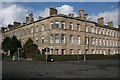
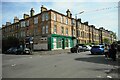
Tenements at corner of Nithsdale Road and Darnley Street
Category B listed tenements, built by Thomson and Turnbull in the 1870s.
Image: © Richard Sutcliffe
Taken: 5 Mar 2017
0.08 miles
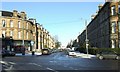
8
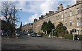
Nithsdale Road
A row of Category B listed tenements on Nithsdale Road. The tower of the former Pollokshields West Church (also Category B listed) can be seen in the distance.
Image: © Richard Sutcliffe
Taken: 5 Mar 2017
0.08 miles
9
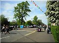
Kenmure Street Festival of Resistance
The event celebrated the 'legacy of the solidarity shown on May 13th 2021; when the community of Pollokshields and beyond, came together to respond to the cruel treatment of refugees and asylum seekers and stood in defiance against the Home Office'. Maxwell Square (behind the trees) was full of people, with musicians, games and food and drink. It was a real community celebration.
Image: © Richard Sutcliffe
Taken: 14 May 2022
0.08 miles
10
Nithsdale Road
A busy junction at Kenmure Street and Glencairn Drive.
Image: © Thomas Nugent
Taken: 6 Jan 2010
0.09 miles