IMAGES TAKEN NEAR TO
Waverley Street, GLASGOW, G41 2DY
Introduction
This page details the photographs taken nearby to Waverley Street, G41 2DY by members of the Geograph project.
The Geograph project started in 2005 with the aim of publishing, organising and preserving representative images for every square kilometre of Great Britain, Ireland and the Isle of Man.

There are currently over 7.5m images from over14,400 individuals and you can help contribute to the project by visiting https://www.geograph.org.uk
Image Map
Images are licensed for reuse under creativecommons.org/licenses/by-sa/2.0
Notes
- Clicking on the map will re-center to the selected point.
- The higher the marker number, the further away the image location is from the centre of the postcode.
Image Listing (48 Images Found)
Images are licensed for reuse under creativecommons.org/licenses/by-sa/2.0
Image
Details
Distance
1
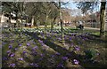
Crocuses, Queen's Park
The Boating Pond is to the right.
Image: © Richard Sutcliffe
Taken: 5 Mar 2017
0.10 miles
4
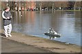
Model warship, Queen's Park Boating Pond
A model of a modern warship, which took the gentleman sailing her about a year to build.
Image: © Richard Sutcliffe
Taken: 5 Mar 2017
0.14 miles
5
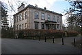
Camphill House, Queen's Park
A Category A listed building, within Queen's Park. constructed circa 1798, for Robert Thomson, a cotton manufacturer. In the late nineteenth century it was acquired by Glasgow Corporation, and for many years operated as Camphill House Museum. It was then used as a store for part of the Burrell Collection, before the purpose-built Burrell Collection building was constructed in Pollok Country Park. It was sold off and converted to flats in 1994, and so is now a residential property again.
Image: © Richard Sutcliffe
Taken: 5 Mar 2017
0.14 miles
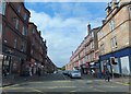
6
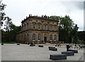
Langside Hall, Glasgow
An 'A' listed building situated on the south side of Glasgow. It was originally built in 1847 as the National Bank of Scotland.
Image: © JThomas
Taken: 14 Sep 2021
0.14 miles
7
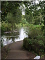
Small pond in Queen's Park
This small duck pond sits above the bigger boating pond in Queen's Park, set among trees in a way that makes it seem more "natural".
Image: © Alec MacKinnon
Taken: 8 Aug 2015
0.15 miles
8
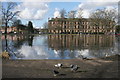
Queen's Park Boating Pond
Looking across to tenements on Pollokshaws Road.
Image: © Richard Sutcliffe
Taken: 5 Mar 2017
0.15 miles
9
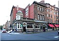
The Butterfly and the Pig
Originally the Corona Bar, designed by architect J.H. Craigie (1870 - 1930) and built by Clarke and Bell in 1912-1913. This distinctive building opened as the Butterfly and the Pig (south) in 2016. There is another bar by the same name in the city centre.
Image: © Richard Sutcliffe
Taken: 15 Aug 2019
0.16 miles
10

Sign for The butterfly and the pig
Public bar at Shawlands https://www.geograph.org.uk/photo/6243226.
Image: © Richard Sutcliffe
Taken: 15 Aug 2019
0.16 miles