IMAGES TAKEN NEAR TO
Nithsdale Road, GLASGOW, G41 2AJ
Introduction
This page details the photographs taken nearby to Nithsdale Road, G41 2AJ by members of the Geograph project.
The Geograph project started in 2005 with the aim of publishing, organising and preserving representative images for every square kilometre of Great Britain, Ireland and the Isle of Man.

There are currently over 7.5m images from over14,400 individuals and you can help contribute to the project by visiting https://www.geograph.org.uk
Image Map
Images are licensed for reuse under creativecommons.org/licenses/by-sa/2.0
Notes
- Clicking on the map will re-center to the selected point.
- The higher the marker number, the further away the image location is from the centre of the postcode.
Image Listing (203 Images Found)
Images are licensed for reuse under creativecommons.org/licenses/by-sa/2.0
Image
Details
Distance
1
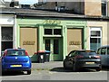
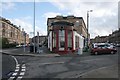
Lunar, Nithsdale Road
A natural wine and cocktail bar. 'Motor Engineers' is above the door. This would appear to date back to a previous business - H. C. Niven & Co, established in 1929, who repaired and serviced old and new vehicles. This had closed by 2008, when it became a cafe called 'Cookie', then 'The Salisbury', followed by 'Niven's'. The property faces onto both Nithsdale Road (seen here) and Nithsdale Street Image
The building is Category B listed https://portal.historicenvironment.scot/designation/LB32394.
Image: © Richard Sutcliffe
Taken: 8 Sep 2023
0.01 miles
2
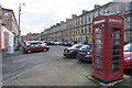
Nithsdale Road
The standard K6 telephone kiosk is Category B listed.
Image: © Richard Sutcliffe
Taken: 5 Mar 2017
0.02 miles
3
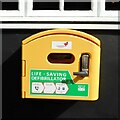
Life-saving defibrillator
On the wall of the Titwood Bar on Nithsdale Road Image
Image: © Richard Sutcliffe
Taken: 8 Sep 2023
0.02 miles
4
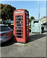
K6 telephone kiosk
A standard K6 telephone kiosk designed by Sir Giles Gilbert Scott in 1935, on Nithsdale Road. It is Category B listed https://portal.historicenvironment.scot/designation/LB32392.
Image: © Richard Sutcliffe
Taken: 8 Sep 2023
0.02 miles
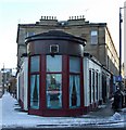
5
New Anand Restaurant
The single storey range with its circular bay at the end is Category B listed. Nithsdale Street runs to the left and Nithdale Road to the right.
Image: © Richard Sutcliffe
Taken: 5 Mar 2017
0.02 miles
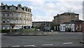
6
New Anand Restaurant
At the sharp end of Nithsdale Street and Nithsdale Road.
Image: © Thomas Nugent
Taken: 6 Jan 2010
0.02 miles
7
Nithsdale Drive at Nithsdale Street
Nithsdale Drive is to the left of the curved building, Nithsdale Street to the right.
Image: © Thomas Nugent
Taken: 6 Jan 2010
0.03 miles
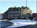
8
Roundabout and tenements
At the junction of Nithsdale Road, Nithsdale Drive and Nithsdale Street.
Image: © Richard Sutcliffe
Taken: 5 Mar 2017
0.03 miles
9
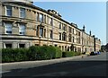
Nithsdale Street
Category B and C listed buildings https://portal.historicenvironment.scot/designation/LB32391 https://portal.historicenvironment.scot/designation/LB32396 https://portal.historicenvironment.scot/designation/LB32395 on Nithsdale Street.
Image: © Richard Sutcliffe
Taken: 8 Sep 2023
0.04 miles
10
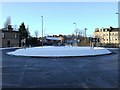
Roundabout at Nithsdale Street
At the junction with Nithsdale Drive.
Image: © Thomas Nugent
Taken: 6 Jan 2010
0.04 miles