IMAGES TAKEN NEAR TO
Payne Street, GLASGOW, G4 0LE
Introduction
This page details the photographs taken nearby to Payne Street, G4 0LE by members of the Geograph project.
The Geograph project started in 2005 with the aim of publishing, organising and preserving representative images for every square kilometre of Great Britain, Ireland and the Isle of Man.

There are currently over 7.5m images from over14,400 individuals and you can help contribute to the project by visiting https://www.geograph.org.uk
Image Map
Images are licensed for reuse under creativecommons.org/licenses/by-sa/2.0
Notes
- Clicking on the map will re-center to the selected point.
- The higher the marker number, the further away the image location is from the centre of the postcode.
Image Listing (298 Images Found)
Images are licensed for reuse under creativecommons.org/licenses/by-sa/2.0
Image
Details
Distance
1
Pinkston Water Sports centre
A pair of ramps under the towing equipment.
Image: © Thomas Nugent
Taken: 29 Jan 2018
0.01 miles
2
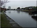
Port Dundas
One of the basins on the disused Monklands Canal at North Canal Bank Street. There are plans to re-connect the basin to the adjacent Glasgow branch of the Forth and Clyde canal.
Image: © Thomas Nugent
Taken: 13 Feb 2009
0.02 miles
3
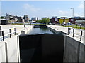
Monkland Canal
Previously, this was a detached section of the Monkland Canal that led to Port Dundas basin. Severed at both ends by the M8 motorway it was left to stagnate. As part of a new regeneration project, a massive land engineering effort went into creating a new hydraulic lock (where none had existed before), to allow boat traffic under the road, and to lead to the junction with the Forth & Clyde canal at Maryhill. The lock shown is expected to be formally opened in 2007.
Image: © Raymond Okonski
Taken: 1 Jun 2007
0.02 miles
4
Port Dundas
One of the basins on the disused Monklands Canal at North Canal Bank Street. There are plans to re-connect the basin to the adjacent Glasgow branch of the Forth and Clyde canal.
Image: © Thomas Nugent
Taken: 13 Feb 2009
0.02 miles
5
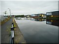
Canal basin, Port Dundas
Port Dundas was the terminus of the Glasgow branch of the Forth and Clyde Canal. It is a Scheduled Monument http://portal.historicenvironment.scot/designation/SM6689. The basin is now used for water sports.
Image: © Richard Sutcliffe
Taken: 24 Jul 2020
0.02 miles
6
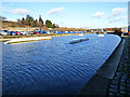
Port Dundas canal basin
Looking across the basin from North Canal Bank Street.
Image: © Thomas Nugent
Taken: 4 Aug 2013
0.02 miles
7
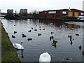
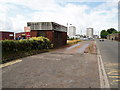
Payne Street
This was originally called Bank Street.
Image: © Richard Sutcliffe
Taken: 24 Jul 2020
0.03 miles
8
Pinkston Water Sports centre
Ramps under the towing equipment.
Image: © Thomas Nugent
Taken: 29 Jan 2018
0.03 miles
9
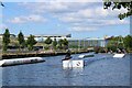
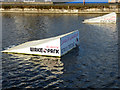
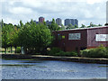
Glasgow Wake Park
Wakeboarding in part of the Forth and Clyde Canal City Branch at Port Dundas. Individual wakeboarders are pulled along by overhead wires suspended from supports (one at each end). At the end of the run, they do a semi-circular turn and are then pulled back again. The floating structures are ramps to jump (as here) or avoid!
Image: © Richard Sutcliffe
Taken: 28 Jul 2024
0.03 miles
10
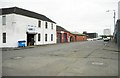
Weighbridge at Port Dundas
Next to the canal basin.
Image: © Gordon Dowie
Taken: 8 Jul 2010
0.03 miles