IMAGES TAKEN NEAR TO
Dalmarnock Road, GLASGOW, G40 4DQ
Introduction
This page details the photographs taken nearby to Dalmarnock Road, G40 4DQ by members of the Geograph project.
The Geograph project started in 2005 with the aim of publishing, organising and preserving representative images for every square kilometre of Great Britain, Ireland and the Isle of Man.

There are currently over 7.5m images from over14,400 individuals and you can help contribute to the project by visiting https://www.geograph.org.uk
Image Map
Images are licensed for reuse under creativecommons.org/licenses/by-sa/2.0
Notes
- Clicking on the map will re-center to the selected point.
- The higher the marker number, the further away the image location is from the centre of the postcode.
Image Listing (40 Images Found)
Images are licensed for reuse under creativecommons.org/licenses/by-sa/2.0
Image
Details
Distance
1
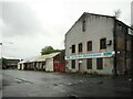
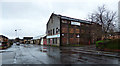
Former business premises
Thomas Stodart Ltd, quality bed manufacturers used to operate from these buildings on Baltic Street. The company ceased trading and was wound up in 2006. The buildings appear to have been vacant since then.
Image: © Richard Sutcliffe
Taken: 28 Jun 2023
0.08 miles
2
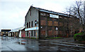
Former business premises
Thomas Stodart Ltd, quality bed manufacturers used to operate from these buildings on Baltic Street. The company ceased trading and was wound up in 2006. The buildings appear to have been vacant since then.
Image: © Richard Sutcliffe
Taken: 28 Jun 2023
0.08 miles
3
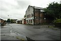
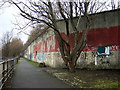
Thomas Stoddart Ltd bed factory
On Baltic Street at Garvald Court. Appears to be disused.
Image: © Thomas Nugent
Taken: 3 Jan 2018
0.09 miles
4
Thomas Stoddart Ltd bed factory
On Baltic Street at Garvald Court. Appears to be disused.
Image: © Thomas Nugent
Taken: 3 Jan 2018
0.09 miles
5
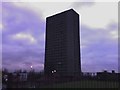
Dalmarnock multi stripped
Flats earmarked for demolition & urban regeneration.
Image: © bill
Taken: Unknown
0.12 miles
7
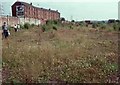
Site of the former Dalmarnock Power Station
The large site of the former power station (demolished in 1980-1981) was left vacant, and became a very interesting site from a botanical point of view, as a large number of wild plants colonised the ground. By 1990 birch scrub was becoming established, along with many Buddleia bushes. These wild flowers attracted many insects, and the large areas of bare ground made a good micro-habitat for sun-loving species which liked to bask there. One of these was the grayling butterfly, which was discovered here in 1989 - the first time it had been recorded within Glasgow. The photograph was taken during a visit by local naturalists to the site in the summer of 1990.
The tenements in the background are on Dalmarnock Road, just north of Dalmarnock Bridge.
Image: © Richard Sutcliffe
Taken: 18 Jul 1990
0.13 miles
8
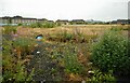
Brownfield site
Between Garvald Street, Baltic Street, Springfield Road and Sunnybank Street. There was the Springfield Centre and a row of tenements with shops along the Springfield Road side until about 2011. These were demolished and the site had temporary structures erected on it for the 2014 Commonwealth Games. It has been left undeveloped since then.
Image: © Richard Sutcliffe
Taken: 28 Jun 2023
0.13 miles
9
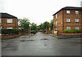
Baltic Court
Looking from Baltic Street.
Image: © Richard Sutcliffe
Taken: 28 Jun 2023
0.13 miles