IMAGES TAKEN NEAR TO
Ashgrove Road, GLASGOW, G40 4BN
Introduction
This page details the photographs taken nearby to Ashgrove Road, G40 4BN by members of the Geograph project.
The Geograph project started in 2005 with the aim of publishing, organising and preserving representative images for every square kilometre of Great Britain, Ireland and the Isle of Man.

There are currently over 7.5m images from over14,400 individuals and you can help contribute to the project by visiting https://www.geograph.org.uk
Image Map (Loading...)


Getting Data...Please wait
Leaflet Map data © OpenStreetMap
Images are licensed for reuse under creativecommons.org/licenses/by-sa/2.0
Notes
- Clicking on the map will re-center to the selected point.
- The higher the marker number, the further away the image location is from the centre of the postcode.
Image Listing (40 Images Found)
Images are licensed for reuse under creativecommons.org/licenses/by-sa/2.0
Image
Details
Distance
3
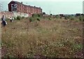
Site of the former Dalmarnock Power Station
The large site of the former power station (demolished in 1980-1981) was left vacant, and became a very interesting site from a botanical point of view, as a large number of wild plants colonised the ground. By 1990 birch scrub was becoming established, along with many Buddleia bushes. These wild flowers attracted many insects, and the large areas of bare ground made a good micro-habitat for sun-loving species which liked to bask there. One of these was the grayling butterfly, which was discovered here in 1989 - the first time it had been recorded within Glasgow. The photograph was taken during a visit by local naturalists to the site in the summer of 1990.
The tenements in the background are on Dalmarnock Road, just north of Dalmarnock Bridge.
Image: © Richard Sutcliffe
Taken: 18 Jul 1990
0.10 miles
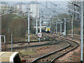
4
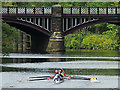
Dalmarnock railway bridge
Looking downstream near Dalmarnock road bridge, the rowers are approaching the second Dalmarnock railway bridge which is located between Dalmarnock and Rutherglen stations on the Argyle Line. The remaining piers of the first (and parallel) railway bridge can be seen through the left arch Image
Image: © Thomas Nugent
Taken: 4 May 2019
0.11 miles
5
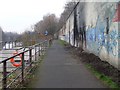
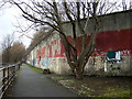
Clyde Walkway, Dalmarnock
Despite the graffiti, the area was rather tranquil.
Image: © Stephen Sweeney
Taken: 18 Feb 2009
0.12 miles
6
Dalmarnock railway bridge
The bridge is seen looking roughly west along the River Clyde.
Image: © Alec MacKinnon
Taken: 14 Jan 2018
0.13 miles
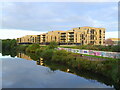
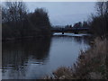
7
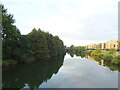
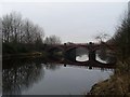
River Clyde
Looking downstream from Dalmarnock Bridge.
Image: © JThomas
Taken: 16 Sep 2021
0.13 miles
8
The Winter West Highland Statesman approaching Rutherglen railway station
The Statesman Rail http://www.statesmanrail.com/ Winter West Highland Statesman on the return journey from Fort William to Hull.
Image: © Thomas Nugent
Taken: 15 Mar 2014
0.13 miles
9
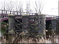
Dalmarnock Rail Bridge
There have been two Dalmarnock Railway Bridges. The first was constructed in 1861
but replaced in 1897 by the current one which is wider. The pillars of the old bridge were left in place as can be seen in the photo. Both of these were designed by George Graham and span the River Clyde.
Image: © Frank Smith
Taken: 9 Feb 2017
0.14 miles
10
Dalmarnock Railway Bridge
Carries the Lanarkshire-bound line between Dalmarnock and Rutherglen stations.
Image: © Stephen Sweeney
Taken: 18 Feb 2009
0.15 miles