IMAGES TAKEN NEAR TO
Finnart Street, GLASGOW, G40 4BJ
Introduction
This page details the photographs taken nearby to Finnart Street, G40 4BJ by members of the Geograph project.
The Geograph project started in 2005 with the aim of publishing, organising and preserving representative images for every square kilometre of Great Britain, Ireland and the Isle of Man.

There are currently over 7.5m images from over14,400 individuals and you can help contribute to the project by visiting https://www.geograph.org.uk
Image Map
Images are licensed for reuse under creativecommons.org/licenses/by-sa/2.0
Notes
- Clicking on the map will re-center to the selected point.
- The higher the marker number, the further away the image location is from the centre of the postcode.
Image Listing (57 Images Found)
Images are licensed for reuse under creativecommons.org/licenses/by-sa/2.0
Image
Details
Distance
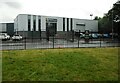
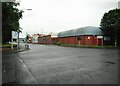
1

Bridgeton Community Centre
Off Old Dalmarnock Road.
Image: © Richard Sutcliffe
Taken: 28 Jun 2023
0.08 miles
2
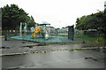
Play area
Off Old Dalmarnock Road.
Image: © Richard Sutcliffe
Taken: 28 Jun 2023
0.10 miles
3
Frontline Safety
Business selling safety equipment of all kinds.
Image: © Richard Sutcliffe
Taken: 28 Jun 2023
0.12 miles
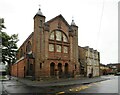
6
Gateway Church
The church is part of the Assemblies of God churches in Great Britain. It was built in 1901 by J C MacKellar, for the Evangelical Union congregation. It closed in 1980, but later re-opened with the current church. It is noted for its Art Nouveau doorpiece and swept roof and is Category B listed https://portal.historicenvironment.scot/designation/LB33825.
Image: © Richard Sutcliffe
Taken: 28 Jun 2023
0.14 miles
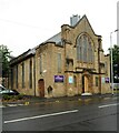
7

Former Bridgeton Free Church
A Category B Listed building http://portal.historicenvironment.scot/designation/LB33825 on Dalmarnock Road. Now known as Gateway Church.
Image: © Thomas Nugent
Taken: 22 Apr 2022
0.14 miles
8
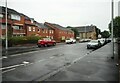
Dalmarnock Road
Looking towards Gateway Church.
Image: © Richard Sutcliffe
Taken: 28 Jun 2023
0.14 miles
9
Road junction
The A749, Dalmarnock Road (running left to right) meets the B763 Dunn Street.
Image: © Richard Sutcliffe
Taken: 28 Jun 2023
0.15 miles
10
Sacred Heart Catholic Church and presbytery
The church is by C J Menart, 1909-10. The adjacent presbytery was built in 1890 and is by Pugin and Pugin. Togather they are Category A listed https://portal.historicenvironment.scot/designation/LB33855.
Image: © Richard Sutcliffe
Taken: 28 Jun 2023
0.15 miles