IMAGES TAKEN NEAR TO
Dalmarnock Road, GLASGOW, G40 4AA
Introduction
This page details the photographs taken nearby to Dalmarnock Road, G40 4AA by members of the Geograph project.
The Geograph project started in 2005 with the aim of publishing, organising and preserving representative images for every square kilometre of Great Britain, Ireland and the Isle of Man.

There are currently over 7.5m images from over14,400 individuals and you can help contribute to the project by visiting https://www.geograph.org.uk
Image Map (Loading...)


Getting Data...Please wait
Leaflet Map data © OpenStreetMap
Images are licensed for reuse under creativecommons.org/licenses/by-sa/2.0
Notes
- Clicking on the map will re-center to the selected point.
- The higher the marker number, the further away the image location is from the centre of the postcode.
Image Listing (187 Images Found)
Images are licensed for reuse under creativecommons.org/licenses/by-sa/2.0
Image
Details
Distance
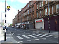
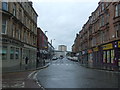
1

Dalmarnock Road
Image: © Thomas Nugent
Taken: 26 May 2013
0.01 miles
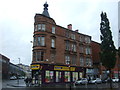
2
Tenement on Dalmarnock Road
Image: © Thomas Nugent
Taken: 26 May 2013
0.01 miles
3
Tenement on Dalmarnock Road
Image: © Thomas Nugent
Taken: 26 May 2013
0.01 miles
5
Dalmarnock Road
Looking away from Bridgeton Cross.
Image: © Thomas Nugent
Taken: 26 May 2013
0.01 miles
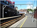
7
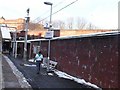
Bridgeton Station
View along the platform from the Glasgow Central to Lanark train.
Image: © Nigel Mykura
Taken: 27 Nov 2010
0.02 miles
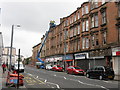
10
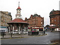
Bridgeton Cross
Bridgeton Cross's best known landmark is 'The Umbrella' which with its clock tower is 50 feet high. It was originally built to shelter the unemployed in 1875.
The road in the background is the A74 looking in the direction of Glasgow City Centre. The road in the foreground leads to roads to Rutherglen and Cambuslang.
Image: © G Laird
Taken: 14 Dec 2008
0.02 miles