IMAGES TAKEN NEAR TO
Queen Mary Street, GLASGOW, G40 3BB
Introduction
This page details the photographs taken nearby to Queen Mary Street, G40 3BB by members of the Geograph project.
The Geograph project started in 2005 with the aim of publishing, organising and preserving representative images for every square kilometre of Great Britain, Ireland and the Isle of Man.

There are currently over 7.5m images from over14,400 individuals and you can help contribute to the project by visiting https://www.geograph.org.uk
Image Map
Images are licensed for reuse under creativecommons.org/licenses/by-sa/2.0
Notes
- Clicking on the map will re-center to the selected point.
- The higher the marker number, the further away the image location is from the centre of the postcode.
Image Listing (139 Images Found)
Images are licensed for reuse under creativecommons.org/licenses/by-sa/2.0
Image
Details
Distance
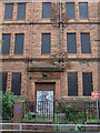
1
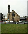
Bridgeton St Francis in the East Church of Scotland
On Queen Mary Street. Built in 1873.
Image: © Richard Sutcliffe
Taken: 28 Jun 2023
0.01 miles
2
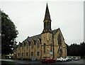
Bridgeton St Francis in the East Church of Scotland
On Queen Mary Street. Built in 1873.
Image: © Richard Sutcliffe
Taken: 28 Jun 2023
0.01 miles
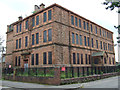
3
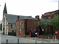
Former Queen Mary Street school
The Janitor's house on the Queen Mary Street side of the building. The church is
St Francis In The East Church of Scotland.
Image: © Thomas Nugent
Taken: 14 Jul 2012
0.02 miles
4
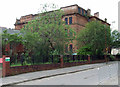
Former Queen Mary Street school
Now hidden behind trees since the school closed in 2009. This is the Bernard Terrace side of the building.
Image: © Thomas Nugent
Taken: 14 Jul 2012
0.02 miles
5
Former Queen Mary Street school
The Boys entrance on Bernard Terrace.
Image: © Thomas Nugent
Taken: 14 Jul 2012
0.03 miles
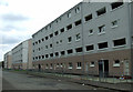
6
Former Queen Mary Street school
Viewed from Bernard Terrace, with Montgomery Street on the right.
Image: © Thomas Nugent
Taken: 14 Jul 2012
0.03 miles
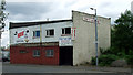
7
Bernard Terrace
Running parallel with London Road at Queen Mary Street.
Image: © Thomas Nugent
Taken: 14 Jul 2012
0.05 miles
9
Bernard Terrace
Runs parallel with London Road.
Image: © Thomas Nugent
Taken: 14 Jul 2012
0.06 miles
10
Mile End Quarter
One of a series of boulders which mark the boundaries of the former hamlet of Mile End. This one is on Avenue Street at London Road. See also Image
Image: © Thomas Nugent
Taken: 14 Jul 2012
0.06 miles