IMAGES TAKEN NEAR TO
St. Vincent Crescent Lane, GLASGOW, G3 8LJ
Introduction
This page details the photographs taken nearby to St. Vincent Crescent Lane, G3 8LJ by members of the Geograph project.
The Geograph project started in 2005 with the aim of publishing, organising and preserving representative images for every square kilometre of Great Britain, Ireland and the Isle of Man.

There are currently over 7.5m images from over14,400 individuals and you can help contribute to the project by visiting https://www.geograph.org.uk
Image Map
Images are licensed for reuse under creativecommons.org/licenses/by-sa/2.0
Notes
- Clicking on the map will re-center to the selected point.
- The higher the marker number, the further away the image location is from the centre of the postcode.
Image Listing (328 Images Found)
Images are licensed for reuse under creativecommons.org/licenses/by-sa/2.0
Image
Details
Distance
1
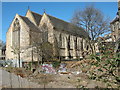
Sandyford Henderson Memorial Church
The rear of the building, seen from Corunna Street.
Image: © Richard Sutcliffe
Taken: 20 Apr 2016
0.01 miles
2
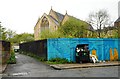
Sandyford-henderson Memorial Church
The church is Category B listed [http://portal.historicenvironment.scot/designation/LB33075] and dates from 1854-6. The ground between the church and Corunna Street is currently vacant and the hoardings in front have been painted by artist Chelsea Frew, in an artwork commissioned by Yorkhill and Kelvingrove community council to brighten up Corunna street.
Image: © Richard Sutcliffe
Taken: 1 May 2019
0.01 miles
3
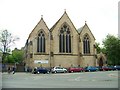
Sandyford Henderson Memorial Church
Image: © Elliott Simpson
Taken: 26 May 2010
0.02 miles
4

Sandyford-Henderson Memorial Church
Category B listed church [http://portal.historicenvironment.scot/designation/LB33075] dating from 1854-56.
Image: © Richard Sutcliffe
Taken: 13 Dec 2018
0.02 miles
5
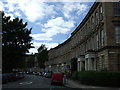
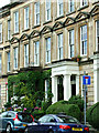
St Vincent Crescent
In the west end of Glasgow.
Image: © Thomas Nugent
Taken: 12 Jul 2008
0.02 miles
6
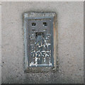
Flush Bracket G253
On Sandyford Church in Kelvinhaugh St, this bracket lies 15.63m above OSDN.
Image: © Keith Edkins
Taken: 14 Sep 2013
0.02 miles
7
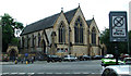
Sandyford Henderson Memorial Church
A large church on a prominent site at the west end of Argyle Street at Kelvinhaugh Street http://sandyfordhenderson.net/ .
A Category B Listed building http://data.historic-scotland.gov.uk/pls/htmldb/f?p=2200:15:0::::BUILDING:33075 .
Image: © Thomas Nugent
Taken: 24 Aug 2014
0.02 miles
8

The Kelvingrove Cafe
The present business on Argyle Street opened in 2013. The owners have stripped back over 100 years of paintwork to reveal the signage for the original Kelvingrove Cafe, which opened in 1896.
Image: © Richard Sutcliffe
Taken: 13 Dec 2018
0.03 miles
9
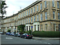
St Vincent Crescent
Corunna Street is to the right.
Image: © Thomas Nugent
Taken: 24 Aug 2014
0.03 miles
10
St Vincent Crescent
Lots on greenery around this doorway near Corunna Street.
Image: © Thomas Nugent
Taken: 24 Aug 2014
0.03 miles